
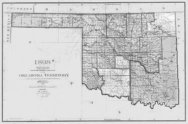
1889 April 22. Oklahoma Territory's First Land Run.
The opening of the Indian lands in Oklahoma Territory was of great interest to people across the United States in the late 1800s. The Indian's desire to keep the Territory for their exclusive use and occupation was complicated by the rapid growth of white population on its northern, eastern, and southern borders; and when the first railroad crossed it (1870-1872), any effort to find an answer became hopeless. The reasons for attempting to obtain lands in "the great American desert" were almost as many as the individuals who made the attempt. Ranchers, Railroads and Boomers sought access to the diverse landscape.
The Unassigned Lands were laid out in 160-acres homesteads, and on 22 April 1889, it was opened to white settlement in the "Run" for farms and town lots, which has become one of the most dramatized episodes in western history. Tent cities sprang up at Oklahoma City, Kingfisher, El Reno, Norman, Guthrie and Stillwater.
The opening of the almost three million acres of Unassigned Lands, created almost as many problems as it solved. All outside the authority of the Indian governments, were without civil law, and in criminal matters they were under the long distance jurisdiction of the Federal court at Fort Smith, Arkansas. The passage of the Organic Act of 2 May 1890 created Oklahoma Territory and allowed the Organization of Government in the central areas; and, the present Panhandle of Oklahoma was declared open to settlement and would be included in Oklahoma Territory. Sections sixteen and thirty-four of each township were reserved for the benefit of public schools. Provision was made for the reservation of public roads on all section lines. Guthrie was designated as the temporary capital.
Oklahoma's First Land Run opened all or part of the present Oklahoma counties of Canadian, Cleveland, Kingfisher, Logan, Oklahoma, and Payne.
Unassigned Lands Oklahoma Territory
http://www.okgenweb.net/~itunassi/index.html
1890 Oklahoma Territorial Census
http://www.okhistory.org/research/1890/index.php
Organization of Oklahoma Territory
http://www.okgenweb.net/~oknowata/OOOT.htm
Kingfisher County Landowners 1906
http://www.okgenweb.net/~okkingfi/landowners.html
No Man's Land, The Panhandle
http://www.okgenweb.net/~okbeaver/NoMansLand/nomansld.htm
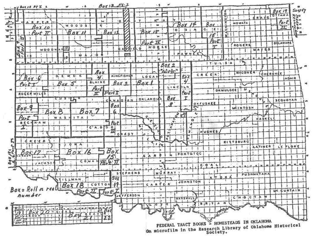
Federal Tract Books of Oklahoma Territory
http://www.sirinet.net/~lgarris/swogs/tract.html
The Tract Books were made when the land was first offered or opened to entry by the Federal Government. The books include people who applied for homesteads or Indian allotments in Oklahoma Territory (not Indian Territory). They do not include allotments of the Five-Civilized Tribes and Osage Indians. SWOGS offers a research service for these books. Click on the title for more information.
Surname Index to the Federal Land Tract Books of Oklahoma Territory
http://www.sirinet.net/~lgarris/swogs/pub.html
22 volumes. Compiled by Anna Billie Clevenger. The Land Tract Books are the records of the first owners of land, showing name, legal description and date of entry for all of Oklahoma Territory. The books are on microfilm, a copy of which is located in the Lawton Public Library. Each SURNAME VOLUME corresponds to a roll of film. $10.00 each volume soft cover. SWOGS will make copies from the film for a fee. The film may also be purchased from the United States Department of the Interior, Bureau of Land Management, P. O. Box 1449, Santa Fe, New Mexico 87504-1449 for $20.00 per roll.
Map of Federal Tract Books - Homesteads in Oklahoma

1891, September 22. Iowa, Sac, Fox, Pottawatomie, and Shawnee Lands.
Lincoln and Pottawatomie Counties (formerly counties "A" and "B") date their beginning from the Land Run of September 22, 1891, which opened to public settlement three Indian reservations adjoining the former Unassigned Lands on the east. Since the Unassigned Lands had been settled 29 months earlier, in the first Land Run April 22, 1889, there had been a steady push for surrounding Indian reservations to also be opened in similar fashion.
President Harrison issued a proclamation September 18, 1891 declaring the surplus Indian lands which had recently been purchased from the Iowa, Sac, Fox, Pottawatomie and Shawnee to be open for settlement four days later, Tuesday, September 22, 1891, at 12 o'clock noon.
A conservative estimate places the number of settlers at about 20,000 surrounding the three reservations awaiting the starting signal for the rush to claim one of the 6,097 160-acre homesteads that were available. Surplus Iowa, Sac and Fox, and Shawnee-Pottawatomie lands were occupied in one afternoon.
Two new counties were carved from the area and were designated "A" and "B" with county seat townsites selected by government officials in the exact geographical center of each. In addition, a considerable amount of land from the reservations was also added to the already existing counties of Payne, Logan, Oklahoma and Cleveland.
Lincoln County, Oklahoma History
http://www.rootsweb.ancestry.com/~oklincol/briefhistory.html
Lincoln County, Oklahoma Territory, Original Land Owners by Township
http://www.rootsweb.ancestry.com/~oklincol/first_names.html
1892, April 19. Cheyenne and Arapaho land opened by land run.
The lands of the Cheyenne - Arapaho country were opened by a "land run," a race for claims in the reservation. About 25,000 hopefuls gathered on a misty morning for the homestead run that began at high noon on April 19, 1892. By sunset over 400 lots in the county seat of "G" had been staked by settlers who rushed in from all directions by foot, race horse, plow horse, wagon, and buggy to claim homesteads. By the end of the first year, April 1893, there were more than 100 homes in Arapaho. By the close of the second year that number had more than doubled. Trail of 100 Years 1892-1992, Arapaho Chamber of Commerce, Arapaho, Oklahoma, 1992.
Counties: "C" Blaine, "D" Dewey, "E" Day (obsolete county combined with Ellis county 1907), "F" Roger Mills,"G" Custer, "H" Washita.
Waiting for the Run 1892
http://www.okgenweb.net/land/run1892.jpg
Cheyenne and Arapaho Lands
http://www.rootsweb.ancestry.com/~itcheyen/
Cheyenne and Arapaho Tribes of Oklahoma
http://www.cheyenne-arapaho.org/
Pioneers of Custer County, Oklahoma
http://freepages.history.rootsweb.ancestry.com/~swokla/custer/custrpb.html
Arapaho ARROW, Custer County, Oklahoma Newspaper 1892
http://freepages.history.rootsweb.ancestry.com/~swokla/custer/arrow.html
Custer County History Links
http://freepages.history.rootsweb.ancestry.com/~swokla/custer/
Western Plains Weatherford Genealogical Society
http://www.rootsweb.ancestry.com/~okcuster/wpwgs.htm
Pioneers of Cheyenne & Arapaho Run 1892
http://www.okgenweb.net/~lands/rmc1892.html
Watonga, Oklahoma
http://www.watonga.com/
Day County, Oklahoma
http://www.ok-history.mus.ok.us/enc/daycounty.htm
Mittie Cobb's 1941 Journal and Pioneer Memories, Arapaho, Oklahoma
http://mittiesjournal.blogspot.com/
1893 September 16. Cherokee Outlet opened by land run.
The Federal Government granted seven million acres of land to the Cherokee Nation in treaties of 1828 and 1835. The United States guaranteed to the Cherokee Nation that this land would be a perpetual outlet west for tribal hunting grounds, measured 58 miles wide and extending 220 miles along the northern border.
After the Civil War, because part of the Cherokee Nation had supported and fought for the Confederacy, the federal goverment demanded new treaty made. They reduced the original reservation lands and permitted "friendly tribes" to be moved into eastern end of the Outlet.
With the start of the cattle drives following the Civil War the Cherokee used their western land to make a profit. The cattlemen wanted to fatten their cattle on the rich grasses before taking them to railheads in Kansas so they leased the land from the Cherokee.
Land hungry settlers viewed the cattlemen's use of the area as a waste of fertile farmland and pressured the government to purchase the Cherokee land from the Cherokee. Congress eventually paid the $8,505,736 or about $1.40 per acre, and announced the opening of the Outlet to homesteaders. Surplus Pawnee and Tonkawa lands were opened at the same time.
President Grover Cleveland designated September 16, 1893 as the date of the "run" for 6,000,000 acres. On that day, 100,000 land hungry persons gathered for the land run into the Cherokee Outlet by horse, train, wagon and even on foot. Each hoped to claim the best farmland or town lot of 40,000 quarter sections. Some hopeful settlers remained landless. Many shunned the rough terrain of the western part of the Outlet, land that went unclaimed for several years. By the end of the day, farms were being established, and the cities of Enid, Perry, Alva, and Woodward had risen out of what had been virgin prairie the day before.
From Caldwell, Kansas 15,000 land hungry whites gathered to make "the Run" south. Caldwell was 1 of 9 places where potential settlers awaited cavalry soldiers' gunshots to start the biggest land rush in the United States.
At the time of the 1893 Land Run, there were 7 original counties: O, L, K, P, Q, M and N. It was decided that the inhabitants of each county could select the name after the run. The names selected were Garfield, Grant, Kay, Noble, Pawnee, Woods and Woodward.
In 1907 when Oklahoma acquired statehood the following counties were made from existing counties in the Cherokee Outlet: Alfalfa County was formed from Woods County; Ellis County was formed from Day and Woodward Counties; Harper County was formed from Indian Lands, Woods and Woodward Counties; Major County was formed from Woods
County.
Cherokee Outlet History
http://www.okgenweb.net/~itoutlet/history.htm
Map of Cherokee Strip and Cherokee Outlet
http://www.usgennet.org/usa/ok/state/outlet/strip.html
List of Names for Cherokee Strip Land Rush
http://www.ausbcomp.com/~bbott/winrr/CherokeeStrip.htm
Picture of Wagons Ready for Run on Cherokee Strip
http://www.ausbcomp.com/~bbott/winrr/v93s16a.htm
The Last Land Rush
http://skyways.lib.ks.us/history/landrush.html
Garfield County Genealogists
http://bjsbytes.com/garfield/
Perry, Oklahoma History
http://www.perryok.org/history.html
Cherokee Strip Museum, Perry, Oklahoma
http://cherokee-strip-museum.org/
1895, May 3. Kickapoo lands opened.
The smallest and LAST land run in Oklahoma was the Kickapoo opening. Of 206,080 acres in the reservation, 22,640 acres were allotted to the Kickapoos in 283 selections of 80 acres each by March 27, 1895. The remaining 183,440 acres purchased by the federal government were opened to settlers in a land run. The Kickapoo lands were added to Lincoln, Oklahoma and Pottawatomie Counties.
1896, March 16. Greer County decision made in United States vs. Texas
Due to an error by the surveyor of the region, and a mistake in indentifying the main channel of the Red River, the southwest corner of Oklahoma, the area between the Red River, the North Fork of the Red River, and the 100th Meridian was claimed by Texas and designated as Greer County in 1860, named for John A. Greer, a Texas lieutenant governor. Greer County, Texas, organized by ranchers in 1886, included all of the current Greer, Jackson, and Harmon Counties and that part of Beckham County south of the North Fork River. To see a map of the disputed territory, click here. The Supreme Court declared in United States vs. Texas, 162 U.S. 1 (1896) Greer County to be a part of Oklahoma Territory. The land office at the county seat of Mangum opened for business by July 2, 1897. Prior settlers of Greer County were permitted to file on the quarter sections they lived on and an adjoining quarter sections where they already had improvements. Within a week 100 homestead entries had been filed, 33 applicants filing for their additional quarter.
At the Constitutional Convention 1907, the area was divided among Beckham County, Jackson County, and Greer County. After statehood 1909, Harmon County was created out of the southwestern portion of Greer County.
Old Greer County Decision 1896
http://freepages.history.rootsweb.ancestry.com/~swokla/greer/greer.html
Old Greer County Map
http://www.okgenweb.net/~okgreer/ogrmap.htm
"A Tale of Two Cities" Duke (Jackson County) Oklahoma
http://freepages.history.rootsweb.ancestry.com/~swokla/jackson/eastduke.html
1901, August 1. Wichita-Caddo and Comanche, Kiowa and Apache lands
The lands of the Kiowa - Comanche country were to be decided by a "land lottery" instead of a race for claims as other openings had. The Fort Sill Miltary Reservation and the Wichita Mountain Forest Reserve were withdrawn from settlement. There were 13,000 quarter sections available. The people had to register at either El Reno or Lawton. The homesteaders were then determined by drawing an envelope which contained a persons name and address. These envelopes were numbered as they were drawn by the land officials. Each person had the opportunity to "stake his claim in turn", according to the number on the envelope. Over 160,000 people registered and obtained their land at El Reno. This was the last large land opening in the present state of Oklahoma.
Canadian County Creation Map
http://www.okgenweb.net/~okcanadi/map1.htm
* The lands of Canadian County were Unassigned Lands east of the 98th Meridian opened by Land Run of 1889. County known as No. 4 in 1890.
* Unallotted Cheyenne and Arapaho land west of the 98th Meridian opened by Land Run of 1892.
* Wichita and Caddo Indian land south of the S. Canadian River opened by Land Drawing in 1901.
Index to Applications for Registration for Homestead Entry
within the Kiowa, Comanche and Apache ceded lands
http://www.sirinet.net/~lgarris/swogs/pub.html
List of registrants for the land lottery for the opening of the Kiowa-Comanche- Apache Lands (now Comanche, Cotton, Tillman, Caddo, Kiowa counties) at Ft. Sill. Does not include list of registrants at El Reno for same lands. SWOGS $10.00 24 pages soft cover
Kiowa, Comanche, Apache
http://www.genealogynation.com/kiowa/
Pauls Valley, Chickasaw Enterprise, Thursday, August 1, 1901
http://www.okgenweb.net/~okbits/
Pauls Valley Lucky Stephen A. Holcomb
Draws Number One in the El Reno District
The first twenty-five names Drawn in the El Reno and Lawton Districts
The Indians at last were allotted a homestead for each member of the respective tribes. In addition, a pasture of half a million acres was reserved for them, which afterward became known as the Big Pasture lands. The Government, also, enlarge the Fort Sill military reservation to eight thousand acres in the Wichita Mountains, neither of these government reservations being open to homesteads. Sites for towns were reserved at all the opening.
On August 6, 1901, the surplus of the Kiowa and Comanche country, amounting to three and one-half million acres, was opened to settlers. This was the last great land opening in OK. Instead of making the race for claims, persons wishing to stake a homestead at the last opening had to register at the Government land offices in El Reno or Lawton. The homesteads were given out by a drawing, called the "land lottery." Each person was assigned a card upon which was his name and address. The card was placed in an envelope and sealed. The land offices received these envelopes for fifteen days. At the end of that time the envelopes were placed in a large box and shuffled. They were then drawn out by the land officials and numbered in order. Each settler staked his claim in turn according to the number on his envelope and card. In this way, there was no trouble with "sooners". Over 160,000 persons registered for homesteads in the opening of the Kiowa and Comanche country. The amount of land for this drawing totaled to three and one-half million acres.
1904 Ponca, Otoe-Missouri and Kaw (Kansas) reservations
These reservations finished allotment by 1904.
Kaw Indian Census and Allotments
Koplowitz, Bradford. The Kaw Indian Census and Allotments, Bowie, Md.: Heritage Books, Inc., 1997. 91p. Paper.
The Kaw Indians, once known as the Kansa or Wind People, were compelled by an 1872 law to move from their homes in Kansas to a new reservation in the Indian Territory of present-day Kay County, Oklahoma. Within a few years the authority of Kaw tribal government had been undermined by federal policies such as the Dawes Act of 1887, which gave land to heads of Indian families
who were willing to relinquish their tribal affiliation for U.S. citizenship. In 1902 the Kaw Allotment Act distributed the remaining lands and put an end to the legal identity of the Kaw tribe. In 1959, however, the Department of the Interior recognized a reconstituted Kaw Nation, which today numbers nearly 2,000 and is headquartered at Kaw City, Oklahoma. This book is a detailed and clearly-arranged guide to the Kaw Indian census of 1887 and the Kaw Indian allotments of 1902-1929. The census entries include the Indian and English names, the relation to head of family, and the age for each of the 193 Kaw enrolled. The allotment records are divided into two sections: 1) farming and grazing leases and 2) oil and gas leases. The allotment records include the names of allottees, lessors and lessees, the lease numbers, the dates of transaction, and legal descriptions of the land tracts. Many of the lessees are companies or non-Indians settlers who did business in the Kay County area of north central Oklahoma. All of these names are included in the more than 700 entries of the index. He has included a synopsis of Kaw history and two maps of the area involved. Mr. Koplowitz is the assistant curator of the University of Oklahoma's Western History Collections and the author of Guide to the Historical Records of Oklahoma. Maps and index.Published 1996 by Willow Bend Books - out of print.
http://www.ok-history.mus.ok.us/gifts/catalog/genealogy.htm -
http://oslo.okcomputer.org/hoisington/kayco/lookups.htm
1906 Osage Allotment Act passed.
Indian Territory was originally founded on the principle that the land would be owned collectively by all tribal members. As the white settlers pushed for even more land the government began to make treaties with the Indians that began a process of allotment whereby each individual member of a tribe would be given their own lot of land. What was left would be sold to white settlers. Once the Natives had their own land they could do with it as they pleased. The Natives in Indian Territory attempted to resist allotment but in 1897 the Seminoles agreed to the Dawes Allotment Act in order to keep at least some of their land from being taken from them. The other Nations of the Five Civilized tribes soon followed suit. Osage land, however, was not allotted until 1906. All the Osage land was divided equally among the tribal members.
Osage Tribe
http://www.osagetribe.com/
1906 December. Big Pasture lands opened by bids.
Drawing for the Big Pasture lands containing a half million acres, was sold in 160 acre tracts to the highest bidders.
Successful Bidders of the Big Pasture Land Opening 1906.
http://www.sirinet.net/~lgarris/swogs/pub.html
Edited and Indexed by Linda Norman Garrison 1992. Compiled from a list published in The Temple Tribune, Cotton County, Oklahoma, 1907. Lists the name of the bidder and their post office address. $10.00 24 pages soft cover.
1907, November 16.
Oklahoma became forty-sixth state to enter the Union.
First Families of the Twin Territories
http://www.rootsweb.ancestry.com/~okgs/fftt.htm
"If you can prove each generation of your lineage back to an individual who settled in one of Oklahoma's territories on or before 16 November 1907, you are eligible for membership in First Families of the Twin Territories."
Oklahoma Township Map Index by Sharon Crawford
http://www.okgenweb.net/twpmaps/index.html
Stephens County was formed from part of territorial Comanche County and part of the former Chickasaw Nation. It was established by members of the Constitutional Convention with the county seat being Duncan.


