
Maps
'n' More
Created
By
Sharon McAllister

|
|
Maps
'n' More |
|
|
|
||
|
|
|
||
|
|
|
|
|
|
|
|
|
|
|
|
|
|
|
|
|
|||
| Index | Canadian | Cleveland | Kingfisher | Lincoln | Logan | Pottawatomie |
Oklahoma County Towns
| RR Station or P.O. |
1895 |
1915 |
1972 |
Township Map |
Near |
| Aero Estates | No | No | No | Deep Fork | |
|
Ambric |
No |
No |
No |
Council Grove |
Tile Works |
|
Arcadia |
|
||||
|
Ball |
No | No |
Deer Creek |
|
|
|
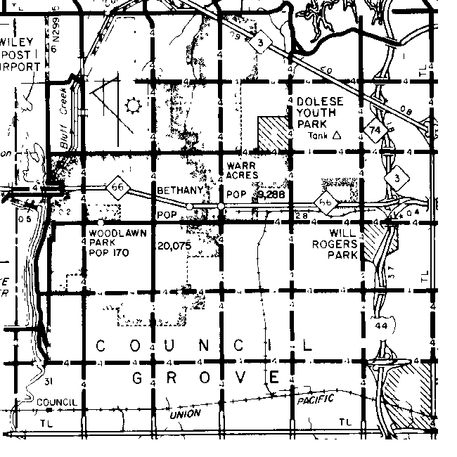
Bethany |
No | No | Council Grove | ||
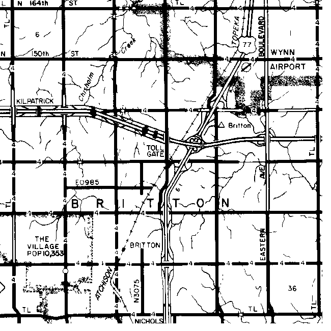
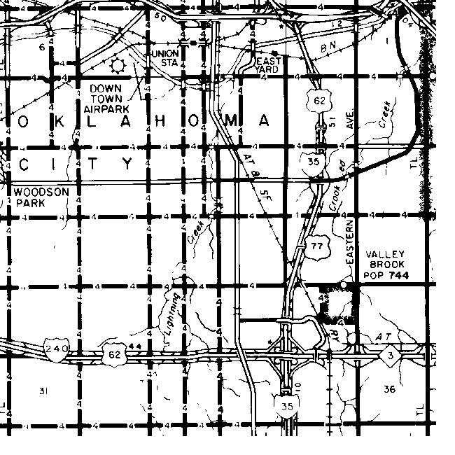
| Britton | Yes | No | Britton | ||
| Capitol Hill | No | No | Greeley | ||
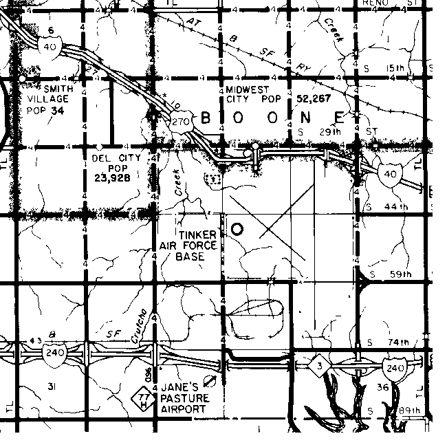
| Carter City | No | No | No | Boone | |
| Cavett | No | No | Elk | ||
| Center | No | No | No | Deer Creek | |
| Chaddick | No | No | No | Crutcho | |
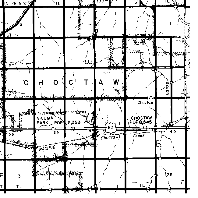
| Choctaw | No | Choctaw | |||
| Conception | No | No | Mustang | ||
| Coon Creek | No | No | No | Deep Fork | |
| Council | No | Council Grove | |||
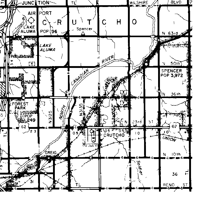
| Crutcho | No | No | No | Crutcho | |
| Del City | No | No | Boone | ||
| Dickson | No | Crutcho | |||
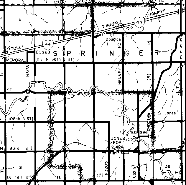
| Douglas | No | No | Springer | ||
| Dunjee Park | No | No | No | Choctaw | |
| Edmond | Edmond | ||||
| Flynn | No | No | Oklahoma | ||
| Forest Park | No | No | No | Crutcho | |
| Garnettville | No | No | Luther | ||
| Glaze |
No |
No | Springer | ||
| Gumbo Pit | No | No | Council Grove | ||
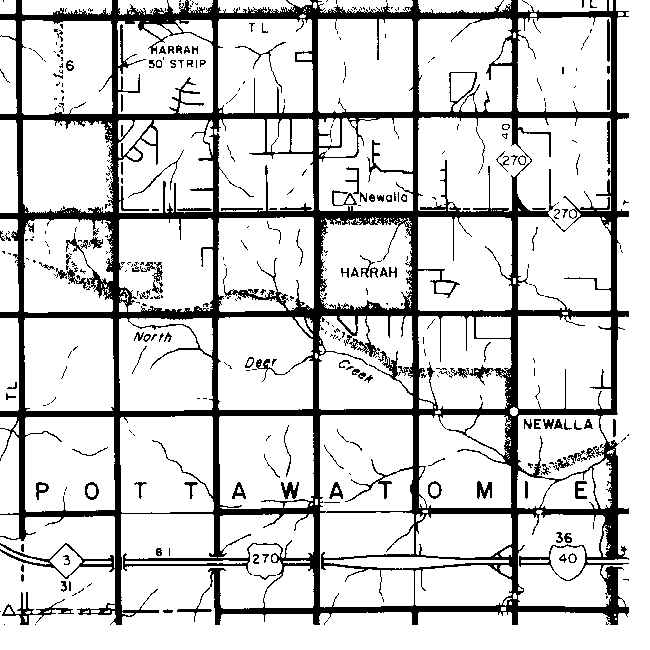
| Harrah | No | Elk | |||
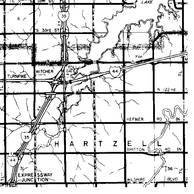
| Hartzell | No | Hartzell | |||
| Hibsaw | No | No | No | Luther | |
| Jay | No | No | Pottawatomi | ||
| Jones |
No |
Yes | Springer | ||
| Lake Aluma | No | No | No | Crutcho | |
| Lake Hiwassee | No | No | Deep Fork | ||
| Lockhart | No | No | Spring Creek | ||
| Ludlow | No | Yes | No | Dewey | |
| Luther | No | Yes | Luther | ||
| Marion | No | Yes | No | Choctaw | |
| Midwest City | No | No | Boone | ||
| Miller | No | No | Spring Creek | ||
| Mishak | No | Yes | No | Boone | |
| Munger | No | Yes | No | Crutcho | Spencer |
| Newalla | No | Yes | Pottawatomi | ||
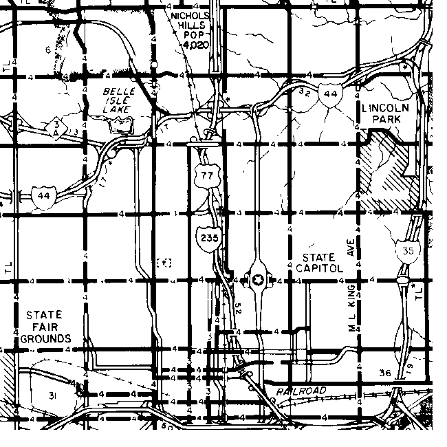
| Nichols Hills | No | No | Oklahoma | ||
| Nicoma Park | No | No | Choctaw | ||
| Oklahoma | Yes | No | Oklahoma | ||
| Oklahoma City | No | No | Oklahoma | ||
| Pennington | No | No | No | Elk | Harrah |
| Servado | Yes | No | Luther | ||
| Shawhoma |
No |
Yes | No | Oklahoma | |
| Shedd | No | Yes | No | Choctaw | |
| Shiloh | No | Yes | No | Oklahoma | |
| Smith Village | No | No | No | Boone | |
| Spencer | No | Yes | Crutcho | ||
| Sweeney | No | No | Elk | Harrah | |
| The Village | No | No | Britton | ||
| Tile Works | No | Yes | No | Council Grove | |
| Valley Brook | No | No | Greeley | ||
| Warr Acres | No | No | Council Grove | ||
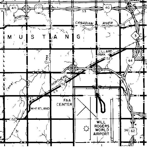
| Wheatland | No | Yes | Mustang | ||
| Whisler | No | No | Deer Creek | ||
| Wing | No | Yes | No | Oklahoma | |
| Witcher | No | Yes | Hartzell | ||
| Woodland Park | No | No | No | Council Grove | |
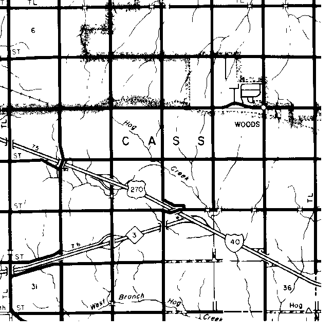
| Woods |
No |
No | Cass |
- A stop and switch on the Rock Island Railroad, 3 miles west of Oklahoma City, but now in the city limits. Took its name from the American Brick Company
- In northeastern Oklahoma County adjoining Oklahoma City. Post office established August 2, 1890. The word means ideal rustic contentment.
- In Oklahoma County, adjoining Oklahoma City on the west. Post office established March 11, 1913. Its name comes from the Biblical community adjoining the city of Jerusalem.
- In Oklahoma County. A post office from November 26, 1889 to November 15, 1950. Municipality consolidated with Oklahoma City by Ordinance No. 6351, effective April 1, 1950. named for Alexander Britton, Washington, D.C., Santa Fe Railway attorney.
- Now part of the area of southern Oklahoma City, and originally a separate municipality. A post office from September 5, 1905 to October 31, 1911, on which date it became a substation to the Oklahoma City post office. The name comes from the circumstance that the area was at one time considered for the location of the state capitol.
- A municipality in Oklahoma County, adjoining Midwest City. Townsite laid out in February, 1948, and consolidated with Del City, September 1, 1954. Named for Charles E. Carter and Edward M. Carter, townsite owners.
- In Oklahoma County, 2 miles southwest of Harrah. A post office from May 24 1892 to October 27, 1898. No longer in existence, it was named for James S. Cavett, early-day resident.
- In Oklahoma County, 8 miles west of Edmond. Post office established March 24, 1890 and named changed to Whisler, June 9, 1890. The name is from the circumstance that the site was the center of the lands open for settlement April 22, 1889.
- In Oklahoma County, 2 miles west of Nicoma Park. Post office established April 16, 1890 and name changed to Dickson, July 17, 1896. Named for Edwin D. Chaddick, railroad official.
- Formerly Choctaw City. In eastern Oklahoma County. Post office established February 21, 1890, and named changed to Choctaw, March 14, 1896. Choctaw took its name from the Choctaw, Oklahoma and Gulf Railroad.
- In southern Oklahoma County. On September 7, 1892, the post office Rosedale in Cleveland County was moved into Oklahoma County, to what is now SW 44 and Meridian in Oklahoma City. Its name was then changed to Conception. Discontinued April 4, 1895. No longer in existence. Its name comes from Conception, Missouri.
- Council Grove - Now within the city limits of Oklahoma City. Post office established June 11, 1892, and named changed to Council, December 7, 1894. Council Grove was the name of a nearby trading post established in 1858 by Jesse Chisholm. Council post office was discontinued August 15, 1906. A stop on the Rock Island Railroad, the depot was removed in 1934 and the site is now a part of Oklahoma City.
- A municipality adjoining Oklahoma City on the southeast. Townsite name, by plat filed September 19, 1946, is Epperly Heights. Named for Delaphene Campbell, daughter of George Epperly, townsite owner.
- Formerly Chaddick.
- In Oklahoma County, 2 miles west of Nicoma Park. Post office name changed to Dickson, July 17, 1896, and discontinued August 15, 1906.
- In northeastern corner of Oklahoma County. A post office from May 12, 2894 to Jun 15, 1900. No longer in existence, it was named for Selwyn Douglas, a prominent Oklahoma City, civil leader. Douglas City - Section 1, Township 13 N, R 1 W; 11 miles north, 15 miles east of Oklahoma City central business district; 1 1/2 miles south, 3 miles west of Luther. more
- In northern Oklahoma County. Post office established May 23, 1889. Named for Eddy B. Townsend, rancher.
- Present Luther, in Oklahoma County. Post office established May 22, 1892, and name changed to Luther, July 26, 1898. Named for Eugene M. Garnett, first postmaster.
- Present Jones, in Oklahoma County. Post office established May 19, 1896, and name changed to Jones, June 1, 1898. Named for Charles D. Glaze, early-day resident.
- Present Newalla, in Oklahoma County. Post office established September 3, 1903, and name changed to Newalla, June 24, 1904.
- Formerly Sweeney. In eastern Oklahoma County. Post office named changed to Harrah, December 22, 1898. Named for Frank Harrah, merchant and business leader.
- In Oklahoma County, 3 miles east of Witcher. A post office from January 27, 1893 to April 2, 1906, it was named for John H. Hartzell, first postmaster.
- North of Luther, on the Oklahoma-Lincoln county line, 2 1/2 miles north of Hwy 66, appears to have been a stop on the Frisco railroad.
- Formerly Rossville.
- Formerly Glaze. In northeastern Oklahoma County. Post office name changed to Jones, June 1, 1898. Named for C. G. Jones, Oklahoma City industrialist and railroad promoter.
- In northeastern Oklahoma County. A post office from July 30, 1897 to August 15, 1900. No longer in existence, its name comes from the Kickapoo Indians.
- NE 63 btwn Bryant Ave and Coaltrane Rd
- In Oklahoma County, 5 miles northwest of Britton A post office from March 21, 1894 to August 15, 1903. No longer in existence, it was named for George D. Lockhart, first postmaster.
- Formerly Garnettville. In northeastern Oklahoma County. Post office established July 26, 1898. Named for Luther Jones, Oklahoma City businessman and son of C. G. Jones.
- In Oklahoma County, southwest of Oklahoma City and now within its city limits. Incorporated August 1, 1951 and dissolved 1963. Named for J. D. McLemore, townsite developer.
- In Oklahoma County, adjoining Midwest City. Townsite developed 1951 and municipality consolidated with Del City, July 8, 1963.
- A separate municipality adjoining Oklahoma City on the southeast. Incorporated March 11, 1943.
- In western Oklahoma County, 6 miles west of Britton. A post office from February 21, 1890 to March 15, 1904. Named for Samuel H. Miller, first postmaster.
- In Oklahoma County, south of present Midwest City. A post office from March 29, 1900 to June 30, 1904. No longer in existence, it was named for Frank Mishak, first postmaster.
- Present Spencer, in northeastern Oklahoma County. Post office established January 16, 1899, and name changed to Spencer, February 25, 1903. Named for G. W. Munger, townsite owner.
- Formerly Halifax. In southeastern Oklahoma County. Post office named changed to Newalla, June 22, 1904. The name is an adaptation of the Osage word for the Canadian River.
- Municipality located north of and adjacent to Oklahoma City. Incorporated 1929; named for G. A. Nichols, Oklahoma City developer and civic leader.
- In eastern Oklahoma County. Post office established February 7, 1929. The named coined from the names Dr. G. A. Nichols, townsite developer, and Oklahoma.
- County seat of Oklahoma County and the capital of Oklahoma since June 11, 1910. Post office established December 30, 1887, as Oklahoma Station. Name changed to Oklahoma, December 18, 1888, and to Oklahoma City, July 1, 1923. Although known since the opening of the Unassigned Lands as Oklahoma City, the post office did not adopt the name Oklahoma City until July 1, 1923.
- The original designation of the stop on the Santa Fe Railway that later became Oklahoma City. Post office established December 30, 1887, and named changed to Oklahoma, December 18, 1888.
- Present Harrah, in Oklahoma County. Post office established March 13, 1894, and name changed to Sweeney, june 22, 1896.
- In Oklahoma County, adjoining Oklahoma City on the northwest and not a separate municipality. Townsite plat filed December 24, 1909. Named for I. M. Putnam, real estate developer and Oklahoma City business leader.
- Formerly Jay. In eastern Oklahoma County. Post office name changed to Rossville, February 21, 1895 and discontinued August 19, 1895. No longer in existence.
- A switch and loading point on the Rock Island Railroad in Oklahoma County, 10 miles east of Oklahoma City. Named for Louis F. Shedd, official of the Choctaw Coal and Railway Company.
- Formerly Munger. In Oklahoma County, 5 miles northeast of Oklahoma City. Post office name changed to Spencer, February 25, 1903. Named for A. M. Spencer, railroad developer.
- Present Harrah, in eastern Oklahoma County. Formerly Pennington. Name changed to Sweeney June 22, 1896 and post office name changed to Harrah, December 22, 1898. Named for E. W. Sweeney, early day settler.
- Adjoining southeastern Oklahoma City. Named for Brigadier General Clarence L. Tinker, killed in action in 1942, while stationed in hawaii as a member of the Army Air Corps.
- Municipality located adjacent to, and northwest of Oklahoma City. Incorporated in 1948; named for C. B. Warr, Oklahoma City developer and civic leader.
- In southwestern Oklahoma County. Post office established February 10, 1902. Took its name from the principal local agricultural product.
- Formerly Center. In northwestern Oklahoma County, 6 miles west of Edmond. A post office from June 9, 1904. No longer in existence, it was named for W. L. Whisler, first postmaster.
- In northeastern Oklahoma County. A post office from January 31, 1903 to may 31 1914. Named for Daniel J. Witcher, townsite owner.
![]()
|
Page last updated
on
Monday, April 20, 2026
This site maintained by
Mel Owings
![]()