Otipoby Cemetery
©2005 Comanche County, OK, OKGenWeb
Transcribed by Margie Etter for Comanche
County OKGenWeb site only, they
may
NOT |

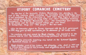
The blue haze of the majestic Wichita Mountains rise sharply to the west of this cemetery, which overlooks the beautiful Cache Creek valley below. It was established by the Comanches in 1888 when they began to abandon their ancient ways of burial in rocky hills and other unmarked locations throughout the Wichita Mountains area. The comanches were warriors of the plains and the most superb riders who ever lived.
After the Comanches signed the Jerome Agreement with the U.S. Government in 1892 they gave up their reservation for an allotment of 100 acres each.
The cemetery site was owned by Hugh Otipoby, who donated it to the comanche tribe in 1929. The United States Army purchased the land in 1942.
The Otipoby Comanche Cemetery was listed on the National Register of Historical Places in 1977.
Hugh Otipoby said of his father, Bob Otipoby, who died in 1937 and is buried here,"Many of his friends and neighbors sleep near him in this old cemetery".

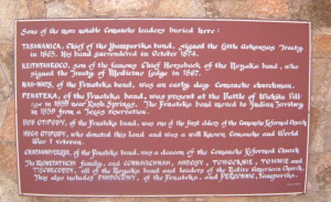
Some of the more notable Comanche leaders buried here:
Tasananica, Chief of Yamparki band, signed the Little
Arkansas Treaty in 1865. He surrendered in October 1874.
Keithtahroco, son of the famous Chief Horseback of the
Noyaka band, who signed the Treaty of Medicine Lodge in 1867.
Nah-Wats, of the Penateka band, was an early day Comanche
churchman.
Panateka, of the Penateka band, was present at
the Battle of Wichita Village in 1859 near Rush Springs. The
Penateka band moved to the Indian
Territory in 1859 from a Texas reservation.
Bob Otipoby, of the Penateka band was one of the
first elders of the Comanche Reformed Church.
Hugh Otipoby, who donated this land and was a well known
Comanche and World War I veteran.
Chatahniyerqui, of the Penateka band, was a deacon
of the Comanche Reformed Church.
The Monetathche family, and Connavichnah,
Ahdosy, Towocknie, Tommie and Tischecoddy, all
of the Noyaka band and leaders of the Native
American Church.
This also includes Pahdocony, of the Penateka,
and Perconnec, Yamparika.


From Interstate 44 at Fort Sill, enter Key Gate. Going west, turn right on Geronimo Road, turn left on Randolph Road, turn right on Quinette Road. Follow "Geronimo Grave" signs. Otipoby Comanche Cemetery is about 1 mile North of Beef Creek Apache Cemetery where Geronimo is buried. Otipoby Comanche Cemetery is on gravel road. Very well kept. If I have made a mistake in transcribing names and dates, I apologize for it.