This list of cemeteries is compiled from many sources: books, maps, geographic server, word-of-mouth, and obituaries.
I will be redoing this page to have all images linked from the
cemetery list for each cemetery. Please bear with me as this change
is happening. I feel this will make for a more user friendly area
for this site. As I'm doing this move and change, if you find broken
links, please let me know so I may fix them. Thank you.
Thank you Jeannie and Elsie for the countless hours you have spent to help all of us. And a very big thank you also goes to Jo Crabtree for countless hours because of her love for Nowata
TRICKY GHOST OF WARD GROVE CEMETERY AND PICTURE
Click Here for a Map of Nowata Co, Cemeteries.
| Armstrong---Journeycake Cemetery | Was located west of Alluwe, but was relocated during the construction of the Oolagah Reservoir to Nowata and is now part of the Nowata Cemetery. (See NOWATA MEMORIAL PARK below.) | Link to Find A Grave Armstrong Cemetery--July 30, 2007 | ||
| Amish Cemetery | Location: South of Hwy 60 on corner of NS 410 & EW 22. | Link to Find A Grave for Amish Cemetery--July 30, 2007 | ||
| Ball Cemetery | Location: On 28 Hwy 1/2 mile south Childers. | See photos of the cemetery | Link to Find A Grave Ball Cemetery --July 30, 2007 | |
| Bezion Cemetery | Location: 4 miles west Nowata on Hwy 60 then 4 miles north on N412 Rd. | See photos of the cemetery | Link to Find A Grave Bezion Cemetery--July 30, 2007 | |
| Bratcher Cemetery | Was located west of Alluwe, but was relocated during the construction of the Oolagah Reservoir to Nowata and is now part of the Nowata Cemetery. (See NOWATA MEMORIAL PARK below.) | |||
| BROWN CEMETERY | Location: 3 miles east Nowata on Hwy 60 turn south on N417. Continue 1/2 miles turn east on N417. | Link to Find A Grave Brown Cemetery--July 30, 2007 | ||
| Buffalo Cemetery | Location: East of Lenapah on Hwy 10 to N417. Before reaching the curve there is a house on south. Cemetery located in private property on river behind house. | The rains of this year 2007, has left this cemetery under probably 10 feet of water. | Link to Find A Grave Buffalo Cemetery--July 30, 2007 | |
| Childers Chapel Cemetery | Location: 2 miles north Childers on N419. On east side of road. | See photos of the cemetery | Link to Find A Grave Childers Chapel Cemetery--July 30, 2007 | |
| Choteau Cemetery | At present location pending, maybe east of South Coffeyville, refer to the Keys Cemetery | |||
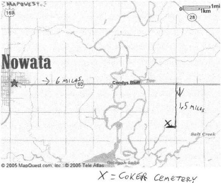
| Coker Cemetery | Location: 5 miles east Nowata on 60 Hwy then N420 south 2 mi. Turn in drive and go thru gate past house and be sure and close the gate. | ---See NEW PHOTOS OF COKER | Directions to Coker Cemetery, Map Courtesy of John Farrell Coker cemetery by John Farrell | Link to Find A Grave Coker Cemetery--July 30, 2007 |
| Forman Cemetery-- | ||||
| Galloway Cemetery or Family-13 | Was located west of Alluwe, but was relocated during the construction of the Oolagah Reservoir to Nowata and is now part of the Nowata Cemetery. (See NOWATA MEMORIAL PARK below.) | |||
| Goodtraveler Cemetery, plus family photos added | Location: 4 1/2 miles north Childers on N419 1/8 mi past EW13. On east side of road on private property. | Photo's of Goodtraveler Cemetery | The rains of this year 2007, has left this cemetery under probably 6-7 feet of water. | Link to Find A Grave Goodtraveler Cemetery--July 30, 2007 |
| Gooseneck, Big Cedar Cemetery | Location: North 10 Hwy 2mi north on CR417 & 1/4 mi west on CR9. Location: Behind a ranch on a small creek, fenced. | mistakenly called Possum Creek Cemetery | The rains of this year 2007, has left this cemetery under probably 10 feet of water. | |
| Headrick Cemetery | On Highway 10 about a mile from the Nowata/Craig County border turn north. Go about four miles north and then the road will jog back to the east for about one-third to one-half mile and then goes back to the north. Two miles north on the northeast corner you will see the old Thompson School. Turn back east and you will see a water tower on the north side of the road. The cemetery is at the base of the tower. | |||
| Hickory Creek Cemetery | Location: 2 miles north of Lenapah on 169 Hwy turn east EW8 for 3/10 miles turn south into pasture on gravel road. | Photo's of Hickory Creek Cemetery | See photos of the cemetery | Link to Hictory Creek Cemetery by Lisa Frye On Find A Grave Site |
| Hopewell Baptist Cemetery--Hopewell Colored Cem | ARE THE SAME AS "TIMBER HILL Cemetery" | |||
| Keys Cemetery | East of South Coffeyville 2 1/2 miles and 1/2 north. This is located on Robert Liebert ranch on 29T 16R 16S. This was allotment land of Lewis Keys. | |||
| Kings Station Cemetery | ||||
| Lain Cemetery | See below, same as Thompson-Lain Cemetery. | |||
| Lincoln Cemetery | Located one mile south of downtown Nowata at the
southwest corner, Block 51, of the Nowata Cemetery. According to a
book by Jeannie Inman, W. J. Davis donated the land as a burial
place for his people. (See NOWATA MEMORIAL PARK below.) |
|||
| LOVE FAMILY CEMETERY | Location: On dead end road N416 & 28 Hwy 5 miles east of Delaware. | |||
| Lowrey/Lowery Cemetery | Just east of Childers. Location: 1/2 mile east of Childers on EW17 in a pasture on southside of road of, Willard Reynolds old place. |
Cemetery photo's taken October 1989 | Link to Find A Grave Lowrey Cemetery--July 30, 2007 | |
| MARTIN CEMETERY | Take State Hwy 28 to Childers, take county road E0160, cross Twin Bridges, turn right on county road N4235 road, go about 1 mile, driveway just before county road E0170 on the right hand side. There has been some confusion as to which county the Martin Cemetery is in. There is no Martin Cemetery in Craig County. | See photos of Martin cemetery |
Link to Martin Cemetery on Find A Grave by Sharlee Farrell and others, includes some photos | |
| McMains Cemetery | Location: 2 miles north 60 Hwy on N424 & EW20. Across the road on the NE side is the old foundation of the Ruby School house. 1 mile on the west side, is the ghost town of Ruby. | Photos included on main page. | Link to Find A Grave McMains Cemetery--July 30, 2007 | |
| Mehlin Cemetery or Family-12 | Was located west of Alluwe, but was relocated during the construction of the Oolagah Reservoir to Nowata and is now part of the Nowata Cemetery, Block 1. (See NOWATA MEMORIAL PARK below.) | |||
| Melton Lake - Choteau Lake Cemetery | Location: East of 169 Hwy on EW3 to N416 then turn back behind house on private property going west. | Link to Find A Grave Melton Cemetery--July 30, 2007 | ||
| Mennonite Cemetery | ||||
| Mt. Washington Cemetery | Located on top of a hill one mile west of Lenapah, Oklahoma. Go west on Lenapah Road, turn right on county road N4130, cemetery can been seen up on the hill. | See photos of the cemetery | See more photosMt. Washington cemetery by John and Sharlee Farrell | Link to Find A Grave Mt. Washington--July 30, 2007 |
| Nowata Memorial Park Cemetery (LINKS ARE BROKEN UP BY NAME AND LISTED BELOW) | Located in Nowata, Oklahoma, this cemetery is really a combination of seven cemeteries: Armstrong-Journeycake*, Bratcher*, Galloway* or Family-13, Lincoln, Mehlin* or Family-12, Memorial Park, and the old Nowata Cemetery (* indicates a relocated cemetery). Records for the cemetery are maintained by the City of Nowata which owns and operates it. The Nowata City Clerk's office will do all they can to assist researchers. They have a map of the cemetery on legal size paper which shows the layout of the blocks and lots. They will answer queries, but the researcher should include as much information as they can on the person they are seeking. Do not send them questions about other cemeteries in the county as they will not have the information you are seeking. | Nowata Memorial Park Cemetery Photos by John and Sharlee Farrell | See photos of the cemetery | Find A Grave Nowata Memorial Park Cemetery |
| Nowata Memorial Park Cemetery (Abbott - Byron) | They have also erected a gazebo in the cemetery where
you can find a list of burials which includes: name; age at death,
if known; burial Block/Lot/Space; and date of death. For more information: Nowata City Hall - Cemetery 701 Modoc Nowata, OK 74048 918/273-3538 |
|||
| Nowata Memorial Park Cemetery (Cable - Dyer) | or you may e-mail Pamela McBride, cemetery clerk at pamelakay1954@hotmail.com Subject must be Cemetery Query. |
|||
| Nowata Memorial Park Cemetery (Eads - Gynther) | ||||
| Nowata Memorial Park Cemetery(Hackler - Hyde) | ||||
| Nowata Memorial Park Cemetery (Icenogle - Kurtz) | ||||
| Nowata Memorial Park Cemetery (Labarr - McWilliams) | ||||
| Nowata Memorial Park Cemetery (Maas - Mykel) | ||||
| Nowata Memorial Park Cemetery (Nading - Quirk) | ||||
| Nowata Memorial Park Cemetery (R - Ryan) | ||||
| Nowata Memorial Park Cemetery (Sage - Symons) | ||||
| Nowata Memorial Park Cemetery(Taber - Voyes) | ||||
| Nowata Memorial Park Cemetery (Wade - Zugar) | ||||
| OVERLEAF-ARMSTRONG CEMETERY | ||||
| Patrick Cemetery or Wann Cemetery--See Wann - Patrick Cemetery below | ||||
| Riley Cemetery | Location: 2 miles north Nowata 169 Hwy turn EW 20 to N417. Cemetery located 1/4 north EW 20 on eastside road behind Jake Riley's house. | |||
| Salt Creek Cemetery---Also called Madden Cemetery | East of Nowata on Highway 60 to 28 and turn south. Right after the turn you will see a cemetery sign pointing back to the west. Go down the lane until you reach a gate. Be sure to close the gate after yourself and go down the lane. The cemetery is just past the creek. | Link to Find A Grave Madden Cemetery known as Salt Creek Cemetery--July 30, 2007 | ||
| Sanders Cemetery | Location: 6 miles east Childers EW16 turn north N423 to
EW15 then follow to N424 going 1 mi north to dead end at cemetery.
. The rains of this year 2007, has left this cemetery under probably 6-7 feet of water. |
|||
| Secondine - Armstrong---once called the Allen Cemetery | Once called the Allen Cemetery since it is on the Allen
alotment land. Location: 5 miles east Nowata 60 Hwy then 2 miles north on N419 then east on D19.8 for 3/10 mile. . The rains of this year 2007, has left this cemetery under probably 6-7 feet of water. |
|||
| Steward Cemetery | Location: N408 in pasture 1/2 mile north EW9 just mile west and north of Lenapah. | |||
| Stop Six - Melton Cemetery | ||||
| Taylor Cemetery---has been known as the Mound - Glendale - Rose and Peck and Taylor Cemetery | Location: 3 miles south Nowata on 169 Hwy then west on EW25 then south on N412 to EW25.5 turn west to dead end road in front of cemetery. | See photos of the Cemetery and new information | Link to Taylor Cemetery Photo's by John and Sharlee Farrell | |
| Thompson - Lain Cemetery | Location: On N424 1/4 north of EW3, on the Nowata-Craig County line. About 2 miles from the old Thompson School. | |||
| Timber Hill - Hopewell Cemetery | Location: 3 miles east of Wann & 2 miles north 10 Hwy on N410.5. | |||
| Wann - Patrick Cemetery | See photos of the cemetery | |||
| Wells Cemetery | Location: East Lenapah on 10 Hwy to N415 turn south 1/2 miles and located eastside of road in middle wheat field. | See Photos of Wells Cemetery Photos July 13, 2007 | ||
| WILLEY CEMETERY | Location: From Nowata go west on 60 Hwy to Glenoak turn north on N404 for 1/4mi. Its fenced on eastside of road. | |||
| Wolfe/Wolf Cemetery | Location: 3 miles north of Childers on N419 turn west on
EW13.5. Road is closed now. Cemetery is in pasture behind Tommy
Stewart's place. . The rains of this year 2007, has left this cemetery under probably 6-7 feet of water. |
Wolfe Cemetery Photo's taken by Jeannie Inman August 17, 1991 |
See surrounding area cemeteries, Manley - Ross Cemetery Craig County Oklahoma
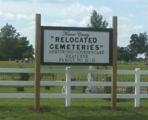
Relocated Cemetery Picture
Link Find A Grave Relocated Cemeteries