Where was Bolin?
In both Oklahoma Place Names and his Oklahoma Chronicles article, Shirk places Bolin in northwestern Delaware County. Bolin's Post Office was in operation from Jan. 27, 1890 to August 22, 1893 when mail was discontinued to Vinita. This suggests that it was close to the Mayes/Delaware County line, certainly northwest of the Neosho River.
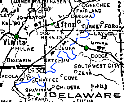
Towns in this area from the 1895 Atlas & Gazetteer |
|
| Afton | In present-day Ottawa County. P.O. established in 1886, shown as RR station on the 1895 map. |
| Albia | In present-day Craig Co., east of Vinita. RR station on 1895 map, P.O. not established until 1899. Oklahoma Place Names says that the name was changed to Todd in 1909. |
| Bolin | In present-day Craig Co. Not shown on the 1895 map, but listed as having a P.O. |
| Echo | In present-day Delaware County. P.O. from July 10, 1882 to Dec 31, 1909. Site inundated by Grande Lake o' the Cherokees. Not shown on the 1915 map, but appears almost due north of Grove on the 1895 map, across the Neosho River. No information regarding successor office. |
| Grove | In present-day Delaware County. P. O. established Dec. 27, 1888. Shown on the east bank of the Neosho River on the 1895 map. |
| Klaus | In present-day Delaware County. P.O. established April 13, 1896. Shown on the south side of the Neosho River on the 1895 map. |
| Needmore | In present-day Delaware County. P.O. established December 14, 1894. |
| Spavinaw | In present-day Mayes County. P.O. established March 14, 1892. |
| Vinita | In present-day Craig Co. P.O. established Sept. 13, 1871, shown as RR station on the 1895 map. |
| Post Offices in operation August 22, 1893 are shown in green. The Neosho River is shown in blue. | |
|
|