
Maps
'n' More
Created
By
Sharon McAllister

|
|
Maps
'n' More |
|
|
|
||
|
|
|
||
|
|
|
|
|
|
|
|
|
|
|
|
|
|
|
|
|
|||
| Back to Oklahoma County Township Maps | Back to Oklahoma County Cemetery Lists |
Oklahoma County - T11N-R2W
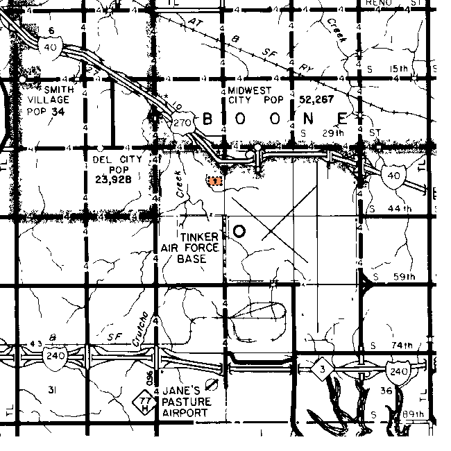
| Cemetery | Directions/Comments/Links | Sec | Latitude | Longitude | Quad |
| Czech Cemetery | 19 | 352513N | 0973320W | Oklahoma City | |
| Kuhlman Cemetery | On Tinker Air Force Base. Kuhlman Canvass | 16 | 352553N | 0972423W | Midwest City |
| Mishak | 24 | ||||
| St. Martin's Cemetery. | Located on SE 74th Street West of Douglas Blvd. Take I-240 east from Oklahoma City. Exit at Douglas Blvd and go north to the first traffic light. Turn left (west) and go less than 1/2 mile. St. Martin's Canvass | 26 or 35 | |||
| Sunnyland | 18 | ||||
| Worley Cemetery | On I-40, go east from the city. Take the Douglas Blvd exit. Go south almost 3 miles on Douglas to 74th Street. Go east on 74th Street almost a mile. The cemetery is on the northwest corner of the intersection of 74th Street and Post Rd, facing 74th Street. Worley Canvass | 36 | 352331N | 0972112W | Choctaw |
Clear Springs Mishak/Mashak Cemetery Located on SE 59th Street about 1/2 mile east of Douglas Blvd. Take I-240 east from Oklahoma City. Exit at Douglas Blvd and go north to SE 59th Street. Turn right (east) and go about 1/2 mile. (Section 24 or 25)
Sunnyland should be in this township, but I didn't find it on the topographic map.
Click on cemetery name for more details from GNIS. Use Lat/Long and Quad name for consulting conventional maps or searching Terraserver and Topozone for cemeteries not shown here.
![]()
|
Page last updated
on
Tuesday, July 21, 2026
This site maintained by
Mel Owings
![]()