
Maps
'n' More
Created
By
Sharon McAllister

|
|
Maps
'n' More |
|
|
|
||
|
|
|
||
|
|
|
|
|
|
|
|
|
|
|
|
|
|
|
|
|
|||
| Back to Oklahoma County Township Maps | Back to Oklahoma County Cemetery Lists |
Oklahoma County - T14N-R1E
Click on Cemetery Name for links to online information such as canvasses.
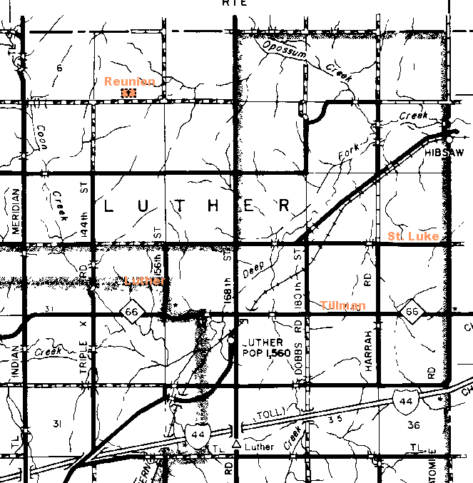
| Cemetery | Directions/Comments/Links | Sec | Latitude | Longitude | Quad |
| Luther | On 156th St., ½ mile north of Hwy. 66, obscured on this map by the OKC Corporate Boundary. Includes Garnettvile's Valley View. Go to GNIS Map, List of Burials, or 2000 Canvass | 20 | 354028N | 0971242W | Luther |
| Reunion | See Map. Go to GNIS Map, 1999 Canvass, or 2000 Canvass | 5 | 354239N | 0971315W | Luther |
| St. Luke | One mile north of Hwy. 66 and ½ mile east of Harrah Road. Go to GNIS Map 2000 Canvass | 13 | 354051N | 0970856W | Luther |
| Tillman | On Hwy. 66 1 ½ miles east of Luther Rd. Go to GNIS Map. 2000 Canvass | 23 | 354004N | 0971005W | Luther |
| Valley View | Garnettville's cemetery, see Luther. Plot Map. List of Burials. | 20 |
![]()
|
Page last updated
on
Wednesday, July 22, 2026
This site maintained by
Mel Owings
![]()