|
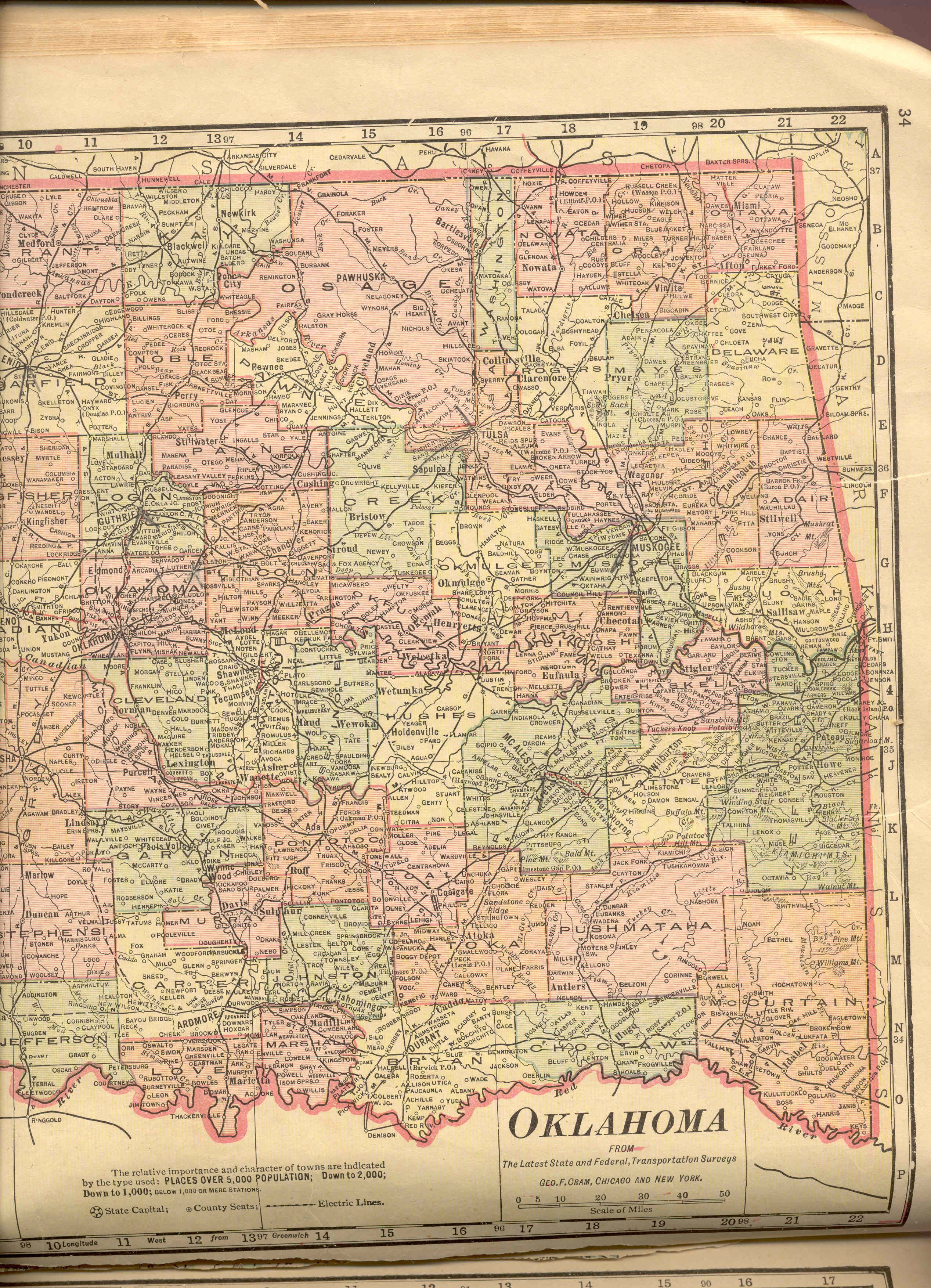
Railroads in Oklahoma in 1915
Under Construction 05/15/2006
The stations listed for each railroad were transcribed from the 1915 map:
| Western OK |
Covers from the western border to a line far enough east of Oklahoma City to
show the entire route of the original Santa Fe tracks in Oklahoma. |
|
Eastern OK |
Covers from the eastern border to a line far enough west
of Enid and Chickasha to show the entire route of the original Chicago,
Rock Island and Pacific tracks in Oklahoma. |
Abbreviations
are from the map, with full names taken from other sources when available.
Wherever possible, I have included information
about predecessor and successor lines, but not all of the already-abandoned
railroads or ones that were built later are included.
Routes are still being transcribed so some did extend past the sections that have been
covered so far.
Click on any of these links to see the railroad's list of stations.
| Acronym |
Source |
Full Name & Comments |
| A. T. & SF. |
1915 & 1972 Maps |
Atchison, Topeka and Santa Fe |
| B. E. & S. |
Kirk |
Blackwell, Enid, and Southwestern |
| B. M. & E. |
Kirk |
Beaver, Meade & Englewood |
| B. N. |
1986 Atlas |
Burlington Northern. Successor line after 1972. |
| C. O. & G. |
Kirk |
Choctaw, Oklahoma & Gulf |
| C. & O. W. |
1915 Map & Kirk |
Clinton and Oklahoma Western |
| C. RI. & P. |
1915 & 1972 Maps |
Chicago, Rock Island, and Pacific |
| C. S. L. |
1915 Map & Kirk |
Cheyenne Short Line |
| C. & S. |
Kirk |
Colorado & Southern |
| F. S. & W. |
1915 Map & 1986 Atlas |
Fort Smith and Western |
| FMR. C. |
1986 Atlas |
Farmrail Corporation |
| FW. & D. |
Kirk |
Fort Worth & Denver |
| H. & E. |
1972 Map |
Hollis and Eastern |
| K. C. S. |
1986 Atlas |
Kansas City Southern |
| K. Cy. M. & O. |
1915 Map & Kirk |
Kansas City, Mexico and Orient. |
| K. O. & G. |
1915 Map & 1986 Atlas |
Kansas, Oklahoma and Gulf. |
| M. K. T. |
1915 & 1972 Maps |
Missouri, Kansas, Texas. Locally known as the
"Katy". |
| ML. & CO. |
1915 Atlas |
Full Name Unknown |
| M. P. |
1986 Atlas |
Missouri Pacific |
| M. V. |
Kirk |
Missouri Valley |
| N. C. OK. |
1986 Atlas |
North Central Oklahoma |
| N. E. O. |
Kirk |
Interurban railway in northeastern Oklahoma |
| N. P. |
Kirk |
Northern Pacific |
| NW. O. |
1986 Atlas |
Northwest Oklahoma |
| O. & N. W. |
1915 Map |
Full Name Unknown. Shown as a proposed line on the 1915 map. |
| O. C. |
Kirk |
Oklahoma Central |
| O. C. A. A. |
1915 Map & Kirk |
Oklahoma City, Ada & Atoka |
| O. K. T. |
1986 Atlas |
Oklahoma, Kansas, Texas |
| O. N. M. & P. |
1915 Map & Kirk |
Oklahoma, New Mexico & Pacific |
| O. Ry. Co. or O. R. C. |
Interurbans & Kirk |
Oklahoma Railway Company |
| O. SW. |
Kirk |
Oklahoma Southwestern |
| O.U.R. |
Interurbans & Kirk |
Oklahoma Union Railway |
| P. C. |
1986 Atlas |
Port of Catoosa |
| P. C. Ry. |
Interurbans & Kirk |
Pittsburg County Railway |
| R. Shortline |
1915 Map |
Full Name Unknown |
| S. K. O. L. |
Kirk |
South Kansas & Oklahoma (Short Line) |
| S. S. |
1986 Atlas |
Sand Springs |
| S. SW. |
1986 Atlas |
St. Louis Southwestern |
| St. L. & S. F. |
1915 & 1972 Maps |
St. Louis and San Francisco |
| T. NW |
1986 Atlas |
Texas Northwestern |
| T. O. & E. |
1915 & 1972 Maps |
Texas, Oklahoma and Eastern |
| T. S. R. |
Interurbans & Kirk |
Tulsa Street Railway |
| T. S. U. |
1986 Atlas & Kirk |
Tulsa-Sapulpa-Union |
| U. E. |
Interurbans & Kirk |
Union Electric |
| W. FS. & NW. |
1915 Map |
Full Name Unknown |
| W. F. & NW. |
1915 Map |
Full Name Unknown |
The transcriptions are a searchable resource
but if your area of interest is not yet covered the worksheets posted
under Railroad Maps can be used to locate some settlements for which
there were railroad stations but we have found no records of post offices or
incorporated towns.
|
