| Towns, Cities, Communities and Populated Places |
Bristow
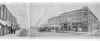
Photos
Post office established April 25, 1898.
Named for Senator Joseph L. Bristow of Kansas.
- more history below -
Cemeteries:
| Bristow City Cemetery aka Oaklawn Cemetery | |
| Magnolia Memorial Gardens | |
| Oak Hill Cemetery aka Fortyfour [44] Cemetery |
Links found online with connections to Bristow
| Galligher | |
| James | |
| Linder | |
| Phillips |
Bristow, located in Eastern Oklahoma, began as a trading post in Indian Territory in 1897. Bristow's history dates back to the opening of the Indian Territory to white settlers. The actual building of Bristow began with the coming of the St. Louis-San Francisco Railroad in July, 1898.
Until Oklahoma statehood, Bristow was under Arkansas law. Bristow is located in the former Creek Nation Indian Territory and was extensively known as the "Woodland Queen" of the Creek Nation.
The City's name, Bristow, is from the Honorable J. L. Bristow, Fourth Assistant Postmaster General at the time the local post office was established.
The Bristow townsite was surveyed by Charles L. Wood in 1901 and approved by the Interior Department in December, 1902. It contained 360 acres divided into 108 blocks of 12 to 24 lots each.
Two of the first things settlers did in 1898 was to organize and erect a small frame school on East Sixth Avenue. In 1899, A. H. Purdy opened Bristow's first bank, The Territorial Bank.
By 1900 most of the area suitable for agriculture was occupied by Creek Indian owners and white tenant farmers. The surrounding land became a little cotton kingdom, several cotton gins were located in Bristow.
In 1920's, Bristow was an oil-boom town. In Oklahoma, minerals such as oil have held a key place in the economy of the state for many years. From 1920 to 1942 Mineral production was the most important source of new wealth in Oklahoma.
Today Bristow has a population of 4,302 people, the only Commercial Airport in Creek County, twenty-six churches and many industries. Bristow is located approximately 35 miles from Tulsa and 1 hour from Oklahoma City.
Traveling West on scenic Route 66 from Sapulpa, Bristow is the site of the National Wake Island War Memorial. The 320 acre park is just six blocks from the heart of downtown Bristow.
The Railroad Depot now houses the Bristow Chamber of Commerce and
the Bristow Historical Society Museum.
Bristow Chamber of Commerce, One Railroad Place, PO
Box 127, Bristow, OK 74010.
Huber Self and Melvin Self, Growing Up in Indian
Territory (Manhattan, Kan. : Ag Press, 1985), 65, 66.
George H. Shirk, Oklahoma Place Names (Norman, OK:
University of Oklahoma Press, 1965).