Your Source For Free Choctaw County Oklahoma Genealogy
Pre-Statehood Maps
*maps from David Rumsey collection - used with permission
1839 | 1844 | 1845 | 1854 | 1855 | 1856 | 1857
1861 | 1864 | 1867 | 1869 | 1872 | 1872 | 1874
1874 | 1874 | 1875 | 1875 | 1878 | 1879 | 1879
1879 | 1882 | 1890 | 1891 | 1900 | 1902 | 1905
*maps from David Rumsey collection - used with permission

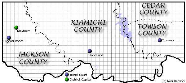
All of present day Choctaw County east of the Kiamichi River
was in Towson County.
The land between the Kiamichi River and the Boggy
River was in Kiamichi County.
All of Choctaw County west of the Boggy River
was in Jackson County.
Jackson & Kiamichi Counites were in the Pushmataha
District. Towson County was in the Apukshunnubbee District.
April Makerney - County Coordinator
Billie Heath - County Assistant
Cindy Burkhalter - County Assistant
All materials on this site are subject to copyright laws. Do not 'contribute' the material (including lists and photos) located on this site to other websites. You may print or save materials to your computer for your personal use only. Any other use of this material requires consent of the copyright holder. This material may not be reproduced in any format for profit or publication by any organization or person.
Area Resources
Bibliography
Choctaw County
Genealogical Society
Oklahoma Historical
Society
Disclaimer
OKCHOCTA is part of the USGenWeb
Project. Links to web sites that are not part of USGenWeb Project are
provided for your convenience and do not imply any endorsement of the
websites or their contents by The USGenWeb Project.