
Your Source For Free Choctaw County Oklahoma Genealogy
Choctaw County Cemeteries
 |
||
|
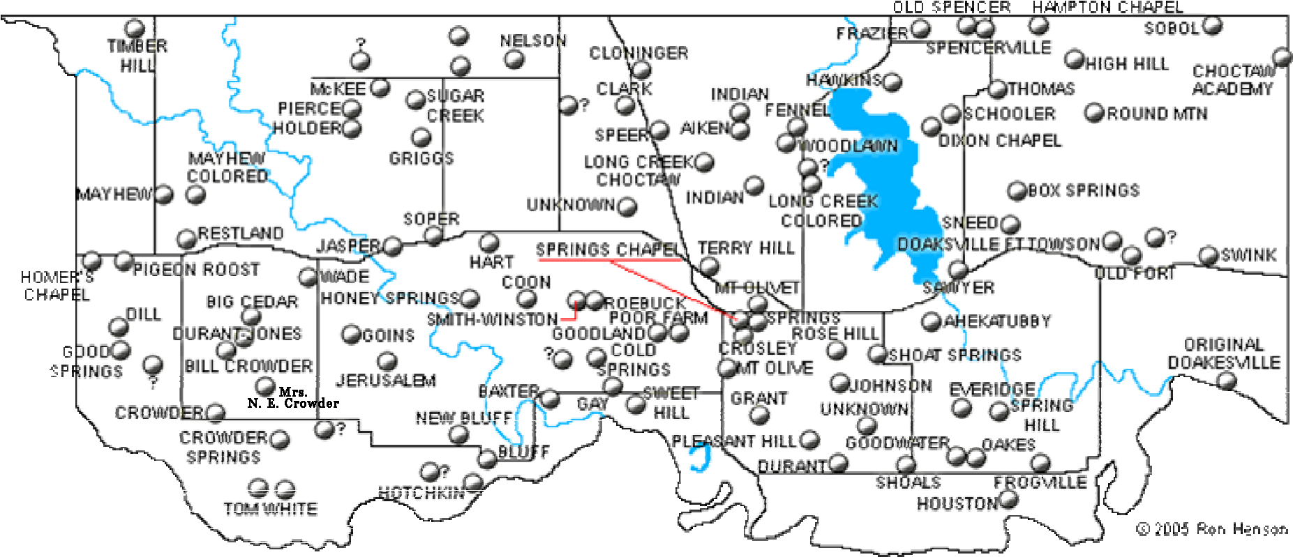
Cemeteries of Choctaw County, Oklahoma (used with permission - photo credit Ron Henson) |
Please remember that all photos are copyrighted by
their submitter.
Do not "contribute" these lists or photos to other
websites.
If the
original submitter wanted it there they would have contributed it
themselves.
Although every effort has been made to identify
cemeteries located on private property, if in doubt always secure
permission before visiting.
Abandoned means no known burials in the
last 25 years.
If you have information about any of these cemeteries or any cemetery or burials in Choctaw County not listed, please email the County Coordinator.
In middle of a clear cut on Gates Creek between Ft. Towson and
Swink.
Existance of cemetery discovered by Veterans
Researcher. General location identified by James Cornwall.
Actual cemetery name unknown. Identified by burial names.
Oldest recorded burial 1901.
Approximately 1 1/2 miles south on section line road at west end of Kiamichi River bridge then approximately 0.2 mile
west. (4300 between 2080 & 2090)
Please note that the landowner does not want people on his property.
An additional canvas done in the 1960's can be found in the Oklahoma Genealogical Society records at this
website.
Private Property Location S35 T6S R18E
MAP 3 Abandoned
Actual cemetery name unknown. Identified by burial names. Reported to be an African American cemetery.
Approximately 6 miles north of Hugo and 1/2 mile west. (2010 between 4220 & 4230)
Neighboring landowner reports approximately 15-20 graves and many Aiken surnames. No further information.
Private Property GPS~ 34.0981N / 95.5131W Location S27 T5S R17E
MAP 3
Relocated to Woodlawn
Alternate name see Sweet Hill
Location S13 T7S R16E
Relocated to Woodlawn
Actual cemetery name unknown. Identified by burial names.
Oldest recorded burial 1916.
Approximately 2 1/2 miles west of Gay Cemetery on south side of highway 109. (2110 between 4150 & 4160)
Only 2 headstones visible between road shoulder and fence line.
Previous enumeration by Tony Thomas, OGS member in 1965
found
here.
Location S11 T7S R16E
MAP 2 Abandoned
Possibly alternate name for High Hill as a Funeral Home record
places burial of
LeAnn Aaron (1 Feb 1931) at Beaver Dam while
enumeration places burial at High Hill. However, the location
remains uncertain.
Described in Snow Funeral Home records as
being "west of Nelson north of Soper" which does not fit High Hill
but does fit Sugar Creek.
Final resting place of Hannah McAfee
(1 Feb 1931).
Actual name of burial site unknown. Identified by burial
names.
Appoximately 900' south of county
line and 1/2 mile west of N4010 Rd.
GPS~ 34.154N
/ 95.896W Abandoned
Location unknown. Only information available is that it was near
Boswell.
Possibly a family burial plot or an alternate name for
an already identified cemetery.
Levina Elizabeth (Bench)
Melson buried there. Bench school located southeast corner of S5
T6S R14E.
2 miles south of Boswell on SH 109 then 2 3/4 miles east on gravel
road. (4040 between 2090 & 2100)
No signage. Not visible from
road.
GPS~ 335832N / 0955011W Location S4 T7S R14E MAP
1
Location unknown. Listed in Snow Funeral Home records as burial
place of Johnson Bob and Ben Byington.
Other Funeral Home
records place burials of Alvin O. Abbott (31-Jan-1930) & J. June
Abbott (15-Feb-1930) at Billy Graveyard while enumeration places
them at Restland.
Alternate name see Pleasant Hill.
Oldest recorded burial 1878. Approx 11 miles
west of US 271 on SH 109 (4130 at 2135)
Cemetery on north
side of road. State sign but no cemetery sign.
GPS~ 335504N / 0954027W Location S30 T7S R16E MAP
2
Alternate name see New Bluff.
Alternate name see Grant.
Listed in Soper Funeral Home records for Rosanna Avery.
Possibly alternate name for Jasper cemetery.
Alternate name see Terry Hill.
Alternate name see Restland.
Oldest recorded burial 1913.
Hwy 147 north from Sawyer 2.3
miles to County Road E2040. East on E2040 2.2 miles to County
Road N4332.
North on N4332 0.4 miles. (4332 between 2030 & 2040)
Next to Box Springs AME Church. Cemetery is well maintained.
Beware of the neighbors dogs.
GPS~ 340343N / 951933W
Location S4 T6S R19E
MAP 4
Alternate name see Mt.Olive.
Alternate name see Mt. Olivet.
Possibly alternate name for Crosley. Various spellings.
Listed in Snow Funeral Home records as burial location for
Edward & infant Alexander while enumeration places their burial
at Crosley.
One listing shows Boswell-Calena. Other Funeral Home
records place burial of Almeta Mitchell Abner (11-Nov-1927)
at
Calena/Colena while enumeration places burial at Crosley.
Actual cemetery name unknown. Identified by burial names.
Located approximately 1/4 mile north of 1980 Rd. & west of 4100
Rd.
Private Property GPS~ 34.1454N
/
95.7375W Location S4 T5S R15E MAP
2
Altername name see Durant.
Alternate name see Long Creek.
Location S12 T5S R20E MAP 4
Oldest recorded burial 1893. Approx 2.25 miles
east of U.S.271 on Speer Road.
Private Property Location S24 T5S R16E MAP
2
3 miles east of U.S. 271 on Speer Road then north 1 mile.
Private Property
Location S12 T5S R16E MAP
2
Oldest recorded burial 1905.
Private Property GPS~ 340005N / 0953613W Location S2 T7S R16E
MAP 2 Abandoned
Actual cemetery name unknown. Identified by burial names. Oldest
recorded burial 1904.
2 miles west of the
junction of U.S. 271 and U.S. 70. Then south 2 miles, east 1/2
mile and south again approx. 1/2 mile.
Please note that you
will have to cross Crowder Creek which may be as deep as 3' and
15' wide.
It is not recommended that automobiles attempt the
crossing except in the dry season.
Private Property Location S29 T6S R16E MAP 2
Abandoned
Alternate name see Johnson.
African-American. Approx. 1/2 mile south of
Springs Chapel Cemetery. No signage.
Barbed wire fence & locked
gate. Maintained.
Location S34 T6S R17E MAP
3
Alternate name see Hart-Indian.
Also known as Hart, Hart-Crowder, Hart-Walker.
North of the Hwy 109 curve, north of the Lake West Road (aka 5
mile corner), abt. 1/4 mile north of that corner on the east
side of the road
is a green mobile home, in the
northwest corner of the yard fence. Information courtesy of
Sherri Cheek.
Location S6 T7S R14E
Located on Rd 2110 near section line 4050.
MAP 1
Previously a reported cemetery.
Located by the Choctaw County
Genealogical Society with the help of Zack Belvin on 9 Oct 2016.
Identified as 6 miles south of Boswell and 1 mile east. North
East of intersection of CR 4030 and SH 109.
Information courtesy of Sherri Cheek.
Location S16 T7S R14E
Oldest recorded burial 1896.
Approximately 10 miles southeast of Boswell on SH 109, 1 mile
south on gravel road, then 1/2 mile west.
Cemetery on north
side of the road. Same location as Crowder Springs school.
GPS~ 33.9251N / -95.80525W Location S23 T7S R14E
MAP 1
Approximately 5 1/2 miles north of US 70
on SH 147 then west 1 mile on gravel road then south 1/4 mile on
gravel road.
Private Property
GPS~ 340544N / 0952307W Location S26 T5S R18E
MAP 3
Reported location.
Pioneer Paper interviews of Thomas Ross
Self and John McCoy Herd place the original Doaksville trading
post
and cemetery on the west bank of Doaksville Creek where it
joins the Red River.
Other sources claim it was at the mouth of
the Kiamichi River.
The cemetery now known as Doaksville is
located at Ft. Towson.
There is no record of burials at the
original site and according to the interviews the cemetery no
longer exists.
The Trading Post moved to near the present
town of Ft. Towson shortly after establishment of the military
fort in 1824.
Private Property
Location S10 T7S R20E
MAP 4
Alternate name see Ft. Towson
No further information.
Oldest recorded burial 1874.
Approximately 2.5 miles east of US 271 on SH 109 then 1/4 mile
north on gravel road.
Private
Property GPS~ 33.9138N / 95.4512W Location S29 T7S R18E
MAP 3 Abandoned
Identified as being north and east of Bill Crowder cemetery
(across the creek on the east side of the road and south of Big
Cedar).
Exact location unknown.
MAP 1
Probable alternate name for Dill.
Alternate name see Long Creek.
Although some maps indicate two cemeteries in the Choctaw / Long
Creek area.
Alternate name see Spring Hill.
Location unknown. Mentioned in a 1930s obituary. Possibly an alternate name for an already listed cemetery.
Oldest recorded burial 1856.
3 miles
east of SH 93 on US 70 to Fallon Road then 5 miles south.
Turn
left on gravel road for approx. 2 3/4 miles.
Cemetery is set
back apporx. 1/10 mile from road.
Will require opening a gate on
the north side of the road and driving across private property
to reach the cemetery.
No signage at gate. There is a house
directly across the road from the gate. The gate has trees on
either side and is easy to miss.
Private Property GPS~ 33.9428N /
95.3667W Location S13 T7S R18E
MAP 3
Actual cemetery name unknown. Identified by burial names.
Oldest burial 1919. 6.7 miles north of Hugo at
Messer.
Private Property
Location S25 T5S R17E
MAP 3 Abandoned
Location unknown. Funeral home records place burial of Billy
R. Billey (20 Jul 1937) & Malissia Polk (20 Jul 1937) at Forney.
Possibly an alternate name for an already listed cemetery.
Also known as Doaksville. Oldest recorded burial 1846.
Cemetery is well maintained.
Take first road north on west
edge of Fort Towson. Go approx. 1 mile north. Cemetery is on the
right surrounded by a rock wall.
GPS~ 34.0327N / 95.2735W Location S13 T6S R19E
MAP 4
Oldest recorded burial 1863.
Military
fort established by Col. Matthew Arbuckle 1824.
East of
present day Fort Towson approx. 1 mile then 3/4 mile north.
Cemetery is located SSW of the Visitor's Center.
According to
the Fort Towson Enterprise, 11 Aug 1905 article, soldiers graves
were removed
to the National Cemetery at Fort Gibson when
the Federal troops abandoned the fort.
GPS~
341603N / 9515502W Location S19 T6S R20E
MAP 4 Abandoned
Actual cemetery name unknown. Identified by burial names.
Oldest recorded burial 1905.
3 miles east
of Hwy 93 on Spencerville Road then 1/2 mile north. On section
line 4310.
Private
Property Location S1 T5S R18E
MAP 3 Abandoned
Oldest recorded burial 1929.
Approx. 10 1/2 miles east of
US 271 on SH 109 then 1/4 mile north on gravel road. Cemetery is
on the left.
GPS~ 33.9107N / 95.3131W Location S34
T7S R19E
MAP 4
Oldest recorded burial 1831.
Approx. 4 miles west of US
271 on SH 109. Cemetery on north side of the road.
Note: CCGS
identifies Gay as Gay/Antioch in error. Land deed indicates
Antioch is an alternate name for Sweet Hill.
Location S11 T7S R16E
MAP 2
From Unger go 2 2/3 miles south, 1 mile east, 1/4 mile south,
then approx. 1/4 mile east.
Location and directions courtesy
of Jim King from information given to him by Clifton Goins.
Cemetery mentioned in the obit of Jim Munday who died at Virgil.
Snow Funeral Home records the burial of J. M. Bridge here as
well.
Private Property
Location S32 T6S R15E
MAP 2
Located 1/2 mile west of Goins. Private Property
Turn south on paved county road at Pigeon Roost Church (2
miles west of Boswell) then south 3 miles.
Turn right (west)
on gravel road 1/2 mile then south approx. 1/2 mile. South of
the Good Springs Church.
Cemetery fenced & maintained.
Signage. Paved road to within 1 mile of cemetery.
Location S2
T7S R13E
MAP 1
Oldest recorded burial 1868.
Approx. 2.5 miles west of US
271 on US 271A on north side of highway. Well marked. Fairly
well maintained.
GPS~ 33.9829N / 95.5598W Location S31
T6S R17E
MAP 3
Also known as Missionary. Oldest recorded burial 1848.
Approx. 7 1/2 miles east of US 271 on SH 109 then 3/4 mile
north.
No easy access. Choctaw Girl's School, 1842.
Private Property GPS~ 335508N /
952154W Location S25 T7S R18E
MAP 3 Abandoned
Approx. 1 mile east of Grant on paved county road. Cemetery
well maintained.
GPS~ 33.9392N / 95.4977W Location S14 T7S R17E
MAP 3
Near Ft. Towson. No further information.
Oldest recorded burial 1940.
2 miles east of junction of
Spencerville Road and SH 147 then 1/2 mile north.
Located at the
extreme north end of Tucker Road.
Location S4 T5S R19E
MAP 4
Alternate name see Hart-Indian.
Also known as Crowder,
Hart-Crowder, Hart-Walker
Alternate name see Hart-Indian.
Also known as Crowder,
Hart, Hart-Walker
Also known as Crowder, Hart, Hart-Crowder, Hart-Walker.
Oldest recorded burial 1869.
2 miles west of US 271 on US 70,
approx. 1/4 mile south then 1/2 mile west through pasture.
Private Property
Location S18 T6S R16E
MAP 2
Alternate name see Hart-Indian.
Also known as Crowder,
Hart, Hart-Crowder
Family cemetery approx. 1/2 mile south of Apple.
Private Property Location S15
T5S R18E
MAP 2
3 miles east of junction of Spencerville Road and SH 147 then
1/2 mile south.
GPS~ 347981N / 9517693W Location S10 T5S R19E
MAP 4
Appox. 2 1/2 miles north of Soper on paved road then 4 miles
west on gravel road then 2 miles north on gravel road.
GPS~
340548N / 954548W Location S29 T6S R15E
MAP 2
Relocated to Sawyer.
Oldest recorded burial 1905.
Close to
US Hwy. Poorly maintained. No signage.
Location S22 T6S R13E
MAP 1
Location approximate. Information needed on location.
Location S25 T6S R15E
MAP 2
Alternate name see Pleasant Hill.
One funeral home uses
Horse Prairie to refer to Grant.
Actual cemetery name unknown. Identified by burial names.
Also known as Living Land. Oldest recorded burial 1896.
Approx. 1 1/2
miles SSW of Bluff Cemetery. From US 271 travel west on Hwy 109
to N4130 approx 10.9 miles.
Turn south and travel to E2138
0.3 miles, continue south to the last fence row 0.4 miles.
Approx. 0.2 miles west to the grove of trees. Living Land
Presbyterian Church, 1856.
Private Property Location S36
T7S R15E
MAP 2 Abandoned
Location approximate. No further information.
No
trespassing with access limited.
Private Property Location S5 T8S R19E
MAP 4
Reported to be an Indian cemetery in S2 T8S R14E.
No
further information.
Reported to be an Indian cemetery approx. 6 miles north of
Hugo and 1/2 mile west. No further information.
Private Property Location S22
T5S R17E
MAP 3
Location unknown. Possibly alternate name for Sobol.
Funeral Home records place burials of Doyle Glen, Elmer Frank &
Lila Lorana Eason at Jackson while enumeration places them at
Sobol.
Exact location unknown. Cemetery reported to be destroyed.
15 burials recorded from funeral home records. Most likely
located in S16 or S21 T6S R15E
MAP 2
Location unknown.
Referred to in Soper Funeral Home records
as burial place for the infant of Fred Caldwell. Infant died 27
Dec 1913.
Actual cemetery name unknown. Identified by burial names.
Oldest recorded burial 1900.
No trespasssing.
Beware of dogs. Identified as Covington (land owner).
Private Property
Location S8 T7S R18E
MAP 3
Altername name see Rose Hill.
Alternate name see Hotchkin-Ussery.
Also known as Choctaw and Earing. Oldest recorded burial
1897.
5.2 miles north of the
intersection of Business US 70 & "H" Street in Hugo. Take "H" St
(at Clayton Avenue Baptist Church) north 10 blocks, turn left
(west) one block then right (north) 4.5 miles. Look for gate
marked "Cemetery Rd" on your right (east) 8/10 of a mile past
intersection. (4210 between 2020 & 2030)
Cemetery is on
private property - inquire about access at the house (Frank
residence) 1/10 mile north of the gate but beware of the dogs.
Cemetery not listed on GNIS.
Also known as Earing although
some maps indicate two cemeteries close to each other.
Additional records at the Oklahoma Genealogical Society's
website.
Private Property Location S33 T5S R17E MAP 3
Oldest recorded burial 1950.
4 miles north of US 70 on SH
93 then approx. 1/8 mile east.
The land
owner requests he be contacted before entering his property.
Private Property Location S7
T6S R18E
MAP 3
Reported to be near East Long Creek School.
Identified in land records as Mayhew Colored. Previously
identifed as Mayhew.
Identified as Mayhaw Colored by Boswell
resident Sherri Cheek.
Alternate name Union Colored.
Approx. 2 1/2 miles north of Boswell.
Location S5
T6S R14E
MAP 1
Location unknown.
Possibly located at Matoy in Bryan County
(S9 T5S R12E).
Funeral home records place burial of Joe E.
Floyd at Maytoy however enumeration places him at Restland.
There is also a Maytoy Cemetery in Atoka County.
Location unknown. Information needed.
Approx. 1/4 mile south of 1990 Rd on 4100 Rd.
Private Property GPS~
34.1256N / 95.7301W Location S15 T5S R15E
MAP 2
Alternate name see Woodlawn.
Relocated to Woodlawn.
Location unknown.
Funeral home records place burial of Jean
Renick Fluellen at Miller Grove however enumeration places
burial at Restland.
Location unknown.
Funeral home records place burial of Dr.
Henry Folsom at this cemetery.
Alternate name see Goodwater.
Location unknown.
Funeral home records indicate this is both
Mt. Olive and Restland. Funeral home reocrds place burial of T.
M. Fennel (31 Dec 1928) at Moran.
Possibly Moran Cemetery
near Wright City in McCurtain County although birth/death dates
of Thomas M. Fennell do not match funeral home record.
Also known as Bray Cemetery.
Located near the County Club
Golf Course near Grant.
Location S10 T7S R17E
MAP 3
Also known as Burgoyne. Oldest recorded burial 1904.
Main
entrance at 8th street & Trice. 2 blocks north of the junction
of US 70 and 8th street.
Excellent access with paved roads
throughout. Cemetery maintenence is excellent.
Showmen's Rest
Section is dedicated to the circus.
GPS~ 33.9989N / 95.5039W Location S29 T6S R17E
MAP 3
Relocated to Woodlawn.
Relocated to Woodlawn.
Located close to old Nelson Store. Two unknown markers are
all that's left.
Last known headstone reportedly removed by
someone from Boulder, Colorado.
No burial information
available. Located two miles west of Nelson-Indian.
Private Property
MAP 2
Oldest recorded burial 1917. Mississippi Choctaws.
Located
2 miles east of Nelson.
Private Property
GPS~ 34.1283N /
95.6521W Location S8 T5S R16E
MAP 2
Location unknown.
Funeral home records place burial of
David E., Nettie O., & Phillip R. Glover at Old Church Nelson
however enumeration places burial at Restland.
Funeral home
records also place burial of Opal Gladish at Old Church Nelson
while enumeration places burial her at Grant.
Unknown if Old
Church Nelson is Grant, Restland or neither. Possible Old Church
Cemetery at Bennington in Bryan County.
Oldest recorded burial 1992.
Located 1/2 mile north of SH
109 on County Road 4120, behind St. Paul Missionary Baptist
Church.
MAP 2
Location unknown.
Possibly Grant as funeral home records
place burial of Julia Gladish at Nonamantube while enumeration
places her at Grant.
Snow Funeral Home records records the
burial of Jacob L. Sneat at this cemetery.
Location unknown.
Mentioned in a 1917 obit for Mrs. Keith.
Possibly an altername name.
Oldest recorded burial 1850.
Approx. 8 1/2 miles east on US
271 on SH 109 then 1/2 mile north.
Private Property GPS~ 335506N / 952132W Location S36 T7S R19E
MAP 4
Location unknown.
Referred to in Soper Funeral Home
records as burial place of Mary I. Dafford (3 Jan 1914).
Alternate name see Dill.
North of Holder Cemetery.
6 miles north of Soper (6 mile
corner) then turn left 4 miles then left 2 miles, cemetery on
left.
Information of burials from Sunny Rae (Pierce) Muncrief
Location T5S R15E
MAP 2
Also known as Pigeon Roost Cumberland Presbyterian Cemetery
Cemetery located
in NW corner of church grounds next to US 70.
GPS~
34.0259N / 95.9049W Location S23 T6S R13E
MAP 1
Cemetery reported to be destroyed.
Location S36 T6S R13E at end of CR (now closed).
Also known as Birdsong & Horse Prairie. Oldest recorded
burial 1906.
Next to Pleasant Hill Baptist Church and across
the road from the historical Birdsong school. The historic Horse
Prairie school was 1 mile east.
Approx. 1 1/2 miles east of
US 271 on SH 109 then 1 mile north on gravel road. Cemetery is
fenced and maintained.
GPS~ 33.9250N / 95.4690W Location
S19 T7S R18E
MAP 3
Possibly an alternate name for Grant. Funeral home records
place burial of Edith & Georgia Gooding at Pollard however
enumeration places them at Grant.
There is also a Pollard
Cemetery in McCurtain County.
Also known as County Farm. Cemetery reportedly destroyed by
landowner.
Approx. 1/2 mile east and 1/4 mile north of
Goodland Cemetery.
Private Property
GPS~ 33.9873N / 95.5508W Location S32 T6S R17E
MAP 3
Also known as Boswell.
A few blocks north of the First
Baptist Church in Boswell. Well marked and maintained.
GPS~
34.0338N / 95.8691W Location S17 T6S R14E
MAP 1
Located just before the little bridges west of the
Oberlin/109 crossroad, on the south side of the road setting
back within the Robison's pasture.
Location S20 T7S R14E
Alternate name see Roebuck.
Location unknown.
Funeral home records place burial of
Josephine Spence at Rock Hill however enumeration places her at
Restland.
The Rock Hill school was located NE of Hugo.
There is also a Rock Hill Cemetery in McCurtain County.
Also known as Rock Comfort. Oldest recorded burial 1864.
West of Hugo on US Hwy approx. 6 miles. South on CR4170 approx.
2.4 miles. Located on east side of road on private property 1/3
mile from road.
Entrance through gates south of Bates residence. Usually
identified on maps and on GNIS as Cold Springs.
Private Property Location S26
T6S R16E
MAP 2
Also known as Jones. Oldest recorded burial 1860.
1 mile
east of SH 93 on US 70 then approx. 1 1/2 miles south on gravel
road. Providence Baptist Mission (1837) at or near site.
Private Property GPS~
335835N / 952656W Location S5 T7S R18E
MAP 3 Abandoned
Oldest recorded burial 1892.
Private Property Location S23 T5S R19E MAP 4
Abandoned
Location unknown.
Funeral home records place burial of R.
L., S. H. & William Spence at Salt Creek however enumeration
places burial at Restland and Grant respectively.
SSnow
Funeral Home records the burial of Sim Christie, Mary
Washington, & Eunice Pisachubbi at this cemetery. As does the
obit for Lucy Pisachubbi.
Actual cemetery name unknown. Identifed by nearby landmark.
Oldest recorded burial 1898.
On east side of section line
4230 between 2030 and 2040.
Private Property GPS~ 34.0616N /
95.5039W
MAP 3 Abandoned
Oldest recorded burial 1906.
East end of the "Dam" road
before it ties back into US 70 at the east side of Sawyer.
"Old Timers" in the area report there are numerous unmarked
graves.
GPS~ 34.0159N / 95.3729W
MAP 3
Actual cemetery name unknown. Identified by nearby landmark.
Oldest recorded burial 1915.
SH 147 north to CR E2010 west
0.4 miles then right (north) 0.2 miles. Cemetery is on the
right.
Private Property
Location S24 T6S R18E
MAP 3 Abandoned
Location unknown.
Possibly alternate name for Grant
although a school called Shade Grove was north of Hugo.
Funeral home records place burial of Joe Spills at Shade Grove
and enumeration places burial at Grant.
Also known as Woods. Oldest recorded burial 1903.
Approx.
5.5 miles east of US 271 on SH 109. Cemetery is on north side of
109 and the west side of Fallon Road (CR4290).
GPS~
33.9107N / 95.3999W Location S27 T7S R18E
MMAP 3
Oldest recorded burial 1906.
3 miles east of SH 93 on US
70 then 2.75 miles south on Fallon Road (CR4290). On west side
of paved road. Maintained.
GPS~ 33.9591N / 95.4175W Location S4
T7S R18E
MAP 3
Relocated to Woodlawn.
Location unknown. Listed as burial location of Rasa(?) Smith (2 May 1917).
Location unknown.
Possibly alternate name for Grant.
Funeral home records place burial of John Spills at Smith and
enumeration places burial at Grant.
Actual cemetery name unknown. Identified by burial names.
Oldest recorded burial 1887.
West of Hugo on US 70 then south
on CR4170 approx 2.4 miles. Cemetery located about 0.4 miles
west of road.
Entrance through gates with nice path to
cemetery. Path goes west and another path cuts back north, which
is where the cemetery lies.
Private Property Location S27
T6S R16E
MAP 2 Abandoned
From US 70, take 1st road east of SH 147 north 1 mile then
east 1 mile. Cemetery in pasture behind house.
Private Property Location S8
T6S R19E
MAP 4
Approx. 11 miles north of US 70 on SH 93 then approx. 8 miles
east, 1 mile north, 4 miles east then 1/2 mile south.
Cemetery located on paved road but requires travel on gravel
roads to reach it. Well maintained.
GPS~ 34.1507N / 95.2092W
Location S3 T5S R20E
MAP 4
Oldest recorded burial 2007.
CR 2000 (Speer Rd) 2 1/4
miles east of US 271 then 1 mile north.
Private Property GPS~ 34.1279N /
95.5879W
Oldest recorded burial 1904.
West side of Soper on US 70.
Fenced & maintained.
GPS~ 34.0333N / 95.7050W Location
S14 T6S R15E
MAP 2
Location unknown.
Possibly alternate name for Restland.
Funeral home records place burial of Ebline Thompson at South
Belvin and enumeration places burial at Restland.
5 miles north of US 70 on US 271
then 3 miles east on gravel road then approx. 1 1/2 miles south
into pasture. Cemetery is fenced.
GPS~ 34.0986N / 95.5643W
Location S30 T5S 17E
MAP 3
Section line 2000 1/2 mile east of 4130 Rd.
Private Property GPS~
34.1139N / 95.6904W Location S18 T5S R16E
MAP 2 Abandoned
Oldest recorded burial 1848.
Private Property Location S6 T5S R19E
MAP 4 Abandoned
Oldest recorded burial 1903.
Approx. 11 miles north of US
70 on SH 93. Turn east to Spencerville approx. 3 1/2 miles on
paved county road.
The cemetery is on the north side of the
road, but isn't visible from the road. Signage on road easy to
miss.
If you come to SH 143 you've gone about 1/4 mile too
far.
GPS~ 34.1461N / 95.3525W Location S6 T5S R19E
MAP 4
Location unknown.
Possibly alternate name for Restland as
funeral home records place burial of Charles William Yoe at
Spring Creek while enumeration places him at Restland.
Also known as Spring and Springs. Oldest recorded
burial 1859.
South of US 70 on 8th Street approx. 200 yards.
On east side of 8th Street next to road. Fenced & maintained.
GPS~ 33.9430N / 95.3476W Location S17 T7S R19E
MAP 4
Also known as Eastern Star. Oldest recorded burial 1917.
Approx. 8 1/2 miles east of US 271 on SH 109 then 2 1/4 miles
north on gravel road.
Cemetery is on the right set back from the road about 200 ft.
Fenced & maintained. Signage next to road and at cemetery.
GPS~ 33.9430N / 95.3476W Location S17 T7S R19E
MAP 4
Oldest recorded burial 1874.
Immediately south of US 70 on
Broadway Street. No access from US 70.
Follow Broadway Street
south from downtown Hugo. The cemetery is located on the left
just past under US 70.
Entrance is at the south end of
cemetery where road curves right to cross railroad track. Well
maintained.
GPS~ 33.9904N / 95.5124W Location S34
T6S R17E
MAP 3
Also known as Nelson. Oldest recorded burial 1885.
6 1/2
miles north of Soper then 1 mile west of Nelson. South on gravel
road approx. 1/2 mile (bearing left at fork).
Cemetery fenced & maintained.
Signage is excellent.
GPS~ 34.1203N / 95.7090W Location
S14 T5S R15E
MAP 2
Location unknown.
Possibly near Sugar Loaf mountain (S22
T5S R12E) in Bryan County, NW of Boswell or Sugar Loaf mountain
in western Pushmataha County, north of Darwin.
Funeral home
records place burial of Frank E. Low at Sugar Loaf while
enumeration places burial at Restland.
Also listed in Soper
Funeral Home records as the burial place of Fannie Walker (18
Jan 1914).
Also known as Antioch. Oldest recorded burial 1921.
Approx. 3 miles west of US 271 on SH 109 then south approx. 2/10
mile on poorly maintained one lane dirt road.
Small sign on
SH 109 indicating where to turn.
Menerva Blunt deeded the
property to the trustees of "Antoach Cemetery" (N. T. McGee, S.
Lemmons, Sam Hollis) February 1924.
GPS~ 335658N /
953419W Location S13 T7S R16E
MAP 2
Also known as Bohannon-Davis. Actual cemetery name unknown.
Identified by nearby landmark. Oldest recorded burial 1910.
Additonal burials from 1966 enumeration by Tony Thomas
found
here.
Private Property GPS~
34.1089N / 95.5247W Location S21 T6S R17E
MAP 3 Abandoned
Actual cemetery name unknown. Identified by burial names.
Oldest recorded burial 1904.
Private
Property Location SW 1/4 S17 T5S R19E
MAP 4 Abandoned
Believed to be near Carnes (Karnes) School.
Location S2
T5S R13E
MAP 1
Location S11 T8S R14E MAP 1
Same section as cemetery identified as Mayhew Colored.
Identified in land records as Union Colored.
Location S5 T6S
R14E
MAP 1
Approx. 5 miles west of Soper on US 70 then 1 mile south at
Unger.
Private Property GPS~
340047N / 954700W Location S24 T6S R14E
MAP 1
Actual cemetery name unknown. Identified by burial names.
1/2 mile south of 1990 Rd, 1/4 mile east of section line 4140.
Private Property
GPS~ 34.1149N / 95.6584W Location S17 R5S R16E
MAP 2
Relocated to Sawyer.
Oldest recorded burial 1901.
6 miles north of US 70 on SH
93 then 7/10 mile west. Cemetery maintained.
GPS~
34.0845N / 95.4816W Location S25 T5S R17E
MAP 3
Alternate name see Shoals.
No information available.
There are multiple cemeteries in the county that are
unidentified. Appoximate locations are given.
f you know the
name of any of these cemeteries, please contact the
County Coordinator.
1. Unknown cemetery just north of section line 2100 west of 4010. MAP 1
2.
UPDATE! Reported cemetery on Rd 2110 near section line 4050.
MAP 1
Cemetery identified as Mrs. N. E. Crowder by
the Choctaw County Genealogical Society with the help of Zack Belvin on 9 Oct 2016.
3. Reported cemetery on Rd 4050 between section lines 2140 and 2150. MAP 1
4. Reported cemetery on section line 4060 between 2140 and 2150. MAP 1
5. Reported cemetery on section line 1980 between 4160 and 4170. MAP 2
6. Reported cemetery north of Rd 1990 west of Rd 4090. MAP 2
7. Unknown cemetery on Rd 2000 east of Rd 4160 MAP 2
8. Reported cemetery on Rd 4160 between 2090 and 2100. MAP 2
9. Reported cemetery near section line 4070 south of Rd 2120. MAP 2
10. Unknown cemetery north of section line 2140 and east of Rd 4110. MAP 2
11. Reported cemetery north of section line 2110 and between 4220 and 4230. MAP 3
12. Reported cemetery north of Rd 2030 between section lines 4190 and 4200. MAP 3
13. Unknown cemetery east of Rd 4250 and north of Rd 2040. MAP 3
14. Reported cemetery south of Rd 2120 and east of section line 4270. MAP 3
15. Reported cemetery on Rd 1990 between section lines 4310 and 4320. MAP 4
16. Reported cemetery between 2050 and 2060 and 4370 and 4380. MAP 4
Any help in identifying and locating the following cemeteries would be greatly apprciated.
Beaver Dam, Billy Graveyard, Calena/Colena, Forney, Maytoy,
Miller Grove, Minnekah, Moran, Mt. A,
Old Church Nelson,
Pollard, Rock Hill, Salt Creek, Shady Grove, Smith, South Belvin,
Spring Creek and Sugar Loaf.
April Makerney - County Coordinator
Billie Heath - County Assistant
Cindy Burkhalter - County Assistant
All materials on this site are subject to copyright laws. Do not 'contribute' the material (including lists and photos) located on this site to other websites. You may print or save materials to your computer for your personal use only. Any other use of this material requires consent of the copyright holder. This material may not be reproduced in any format for profit or publication by any organization or person.
Area Resources
Bibliography
Choctaw County
Genealogical Society
Oklahoma Historical
Society
Disclaimer
OKCHOCTA is part of the USGenWeb
Project. Links to web sites that are not part of USGenWeb Project are
provided for your convenience and do not imply any endorsement of the
websites or their contents by The USGenWeb Project.
